Map Work
Two questions use one outline map of India printed at the end of the paper: Q9 (History, 2 marks) and Q19 (Geography, 3 marks), as in the 2026-27 sample paper. In Q9, two places from the Nationalism in India list are already marked A and B; identify them from the clues and write their names near them. In Q19 you find the places yourself, mark each with a suitable symbol and name it. The 2025 and 2026 papers asked any three of four, with clues such as "a nuclear power plant in Maharashtra"; the sample paper gave one dam OR another, then any two of three. To be safe, give the symbol at the right spot and the name. Visually impaired candidates answer written "Name the place…" questions instead, which are for them alone.
Marks are lost on places that sit very close together, on look-alike names, on coastal places drawn inland or far out at sea, and on clues read only halfway. Here the quiz starts with MCQs on identifying a marked place and moves on to questions about where places lie; the short questions practise Q9 and Q19 separately, and the long questions put both on one map. Where two places are joined by OR, do only one; on the answer maps both carry the same number.
Revise in 5 Minutes
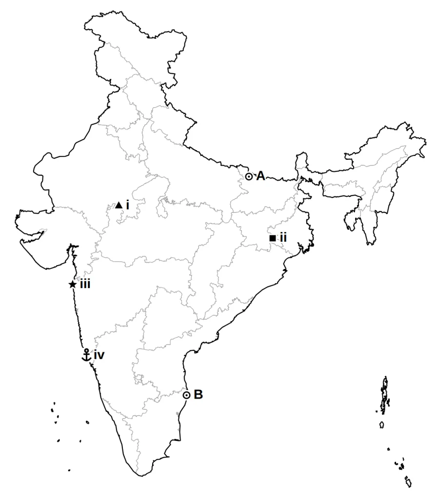
Answer-map symbols: triangle dam · star power plant · square industry or software park · anchor port · plane airport · circle any other place.
History (Q9)
| Place | State | Clue it goes with |
|---|---|---|
| Calcutta | West Bengal | Congress session, September 1920 (east, on the Hooghly) |
| Nagpur | Maharashtra | Congress session, December 1920 (centre of India) |
| Madras | Tamil Nadu | Congress session, 1927 (east coast) |
| Champaran | Bihar | indigo peasants, 1917 (Nepal border) |
| Kheda | Gujarat | peasants and land revenue (just south of Ahmedabad) |
| Ahmedabad | Gujarat | mill workers, 1918; Sabarmati Ashram |
| Amritsar | Punjab | Jallianwala Bagh, 13 April 1919 |
| Dandi | Gujarat | salt law broken, April 1930 (coast, south of Surat) |
Soils: alluvial: northern plains, east-coast deltas · black: Deccan trap · red and yellow: eastern and southern Deccan · laterite: hot, very rainy areas (Kerala, Karnataka, hills of Odisha and Assam) · arid: western Rajasthan · forest: mountain slopes.
Crops: rice: northern and north-eastern plains, coasts, deltas · wheat: Ganga-Satluj plains, Deccan black soil · leaders: sugarcane Uttar Pradesh, tea Assam, coffee Karnataka, rubber Kerala, jute West Bengal, cotton Gujarat and Maharashtra.
Dams: Salal (Chenab, Jammu and Kashmir) · Bhakra Nangal (Satluj, Himachal Pradesh-Punjab) · Tehri (Bhagirathi, Uttarakhand) · Rana Pratap Sagar (Chambal, Rajasthan) · Sardar Sarovar (Narmada, Gujarat) · Hirakud (Mahanadi, Odisha) · Nagarjuna Sagar (Krishna, Telangana-Andhra Pradesh) · Tungabhadra (Karnataka).
| Group | Places |
|---|---|
| Iron ore | Mayurbhanj (Odisha), Durg and Bailadila (Chhattisgarh), Bellary and Kudremukh (Karnataka) |
| Coal | Raniganj (West Bengal), Bokaro (Jharkhand), Talcher (Odisha), Neyveli (Tamil Nadu, lignite) |
| Oil | Digboi, Naharkatia (Assam); Mumbai High, Bassein (sea off Mumbai); Kalol, Ankaleshwar (Ankleshwar) (Gujarat) |
| Thermal | Namrup (Assam), Singrauli (east Madhya Pradesh), Ramagundam (Telangana) |
| Nuclear | Narora (Uttar Pradesh), Kakrapara (Gujarat, inland), Tarapur (Maharashtra coast), Kalpakkam (Tamil Nadu coast) |
| Cotton textiles | Mumbai, Indore (Madhya Pradesh), Surat, Kanpur (Uttar Pradesh), Coimbatore (Tamil Nadu) |
| Iron and steel | Durgapur (West Bengal), Bokaro and Jamshedpur (Jharkhand), Bhilai (Chhattisgarh), Vijayanagar (Karnataka), Salem (Tamil Nadu) |
| Software parks | Noida (Uttar Pradesh), Gandhinagar (Gujarat), Mumbai and Pune (Maharashtra), Hyderabad (Telangana), Bengaluru (Karnataka), Chennai (Tamil Nadu), Thiruvananthapuram (Kerala) |
| Ports | West coast, north to south: Kandla (Gujarat), Mumbai, Marmagao (Goa), New Mangalore (Karnataka), Kochi (Kerala). East coast, south to north: Tuticorin, Chennai, Visakhapatnam, Paradip (Odisha), Haldia (West Bengal) |
| Airports | Amritsar (Sri Guru Ram Das Jee), Delhi (Indira Gandhi), Mumbai (Chhatrapati Shivaji), Chennai (Meenambakkam), Kolkata (Netaji Subhash Chandra Bose), Hyderabad (Rajiv Gandhi) |
Traps
- Look-alikes: Salal and Salem; Narora and Namrup; Durg and Durgapur; Kakrapara and Kalpakkam; Rana Pratap Sagar and Sardar Sarovar.
- Too close to split: Kheda and Ahmedabad; Digboi, Naharkatia and Namrup; Raniganj and Durgapur; Bellary and Vijayanagar.
- Tarapur, Kalpakkam and the ten ports go on the coastline; Kakrapara does not; Mumbai High and Bassein go in the sea.
How to use this page: try each question on paper first, then read the answer. The marks against each step show what an examiner looks for. The 1-mark MCQs are in the quiz at the end, together with questions that test how well you understand the chapter; every quiz answer comes with its explanation.
Short Answer Questions (2 and 3 Marks)
Question 1 (2 marks)
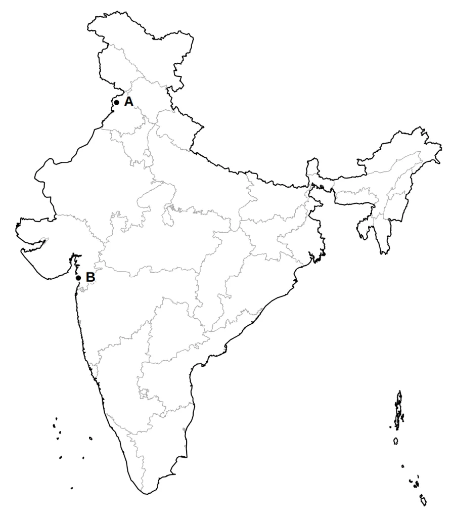
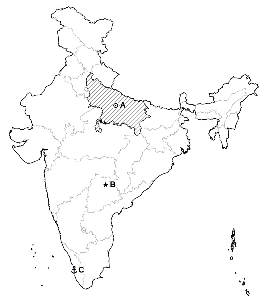
Two places A and B are marked on the outline map of India given below. Identify them with the help of the following information and write their correct names.
A. The Punjab city whose events of April 1919 General Dyer later defended by saying that his aim had been to 'produce a moral effect'.
B. The coastal village that Gandhiji and his 78 volunteers reached after walking for 24 days in 1930.
Answer.
Model answer:
A. Amritsar: Punjab, in the north-west, near the Pakistan border.
B. Dandi: Gujarat, on the coast, south of Surat.
In the zoomed box, B is Dandi; 1 is Ahmedabad and 2 is Kheda, the other Gujarat places on the list.
Marking scheme:
- A: Amritsar — 1 mark
- B: Dandi — 1 mark
Question 2 (2 marks)
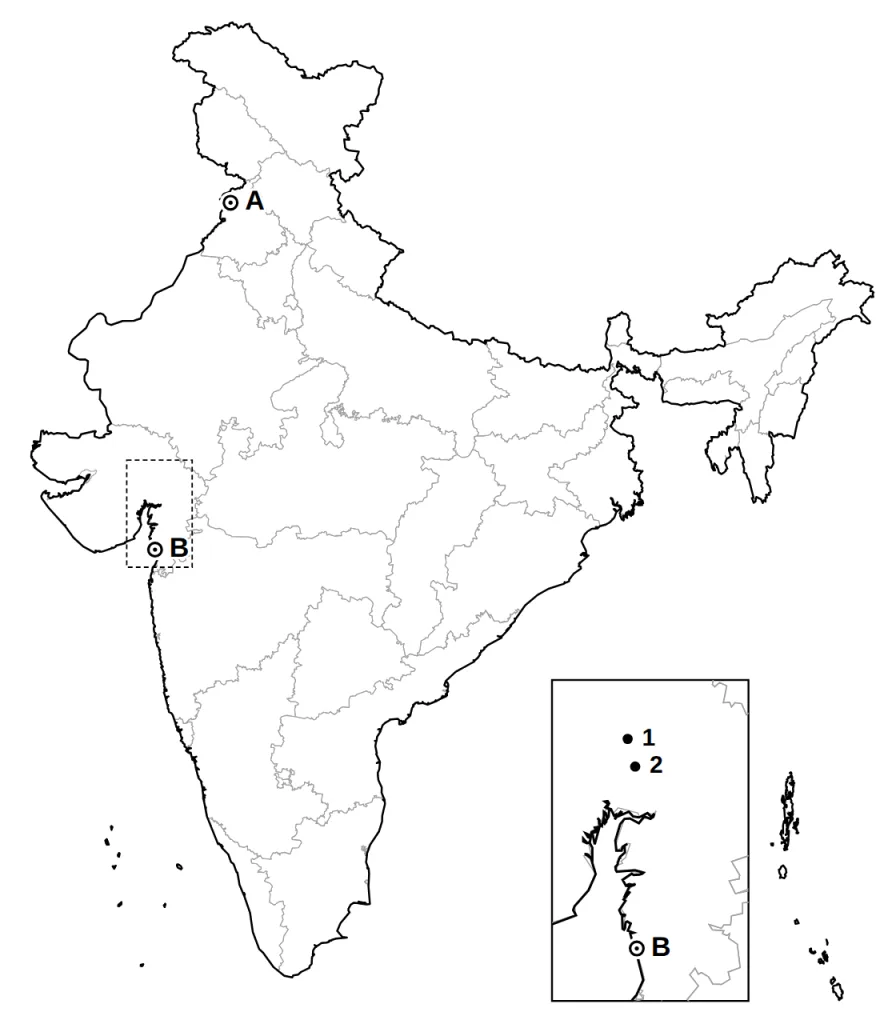
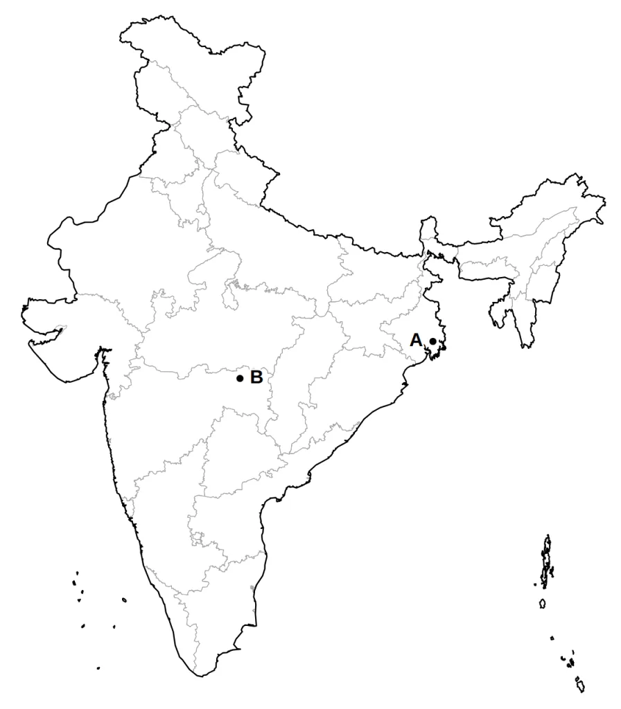
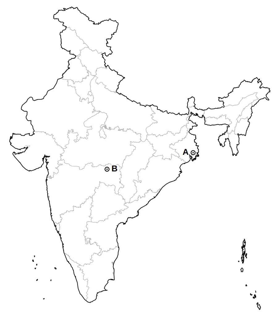
Two places A and B are marked on the outline map of India given below. Identify them with the help of the following information and write their correct names.
A. The first of the two Congress sessions of 1920, held in September, met in this city on the Hooghly.
B. The second session, in December 1920, met in this city. Its region was the one where industrial workers joined the Civil Disobedience Movement in large numbers.
Answer.
Model answer:
A. Calcutta (now Kolkata): West Bengal, in the east, on the Hooghly near the Bay of Bengal.
B. Nagpur: Maharashtra, in the east of the state, almost at the centre of India.
Marking scheme:
- A: Calcutta (now Kolkata) — 1 mark
- B: Nagpur — 1 mark
Question 3 (3 marks)
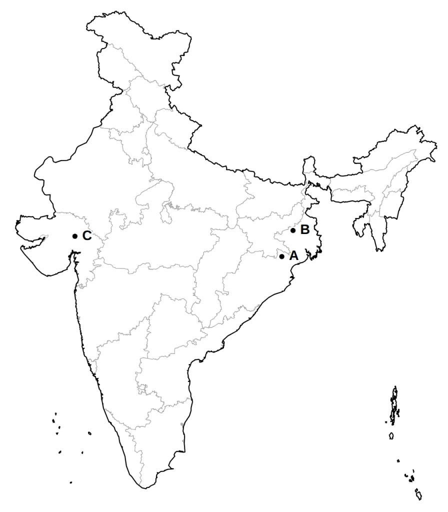
Three places A, B and C are marked on the outline map of India given below. Identify them with the help of the following information and write their correct names.
A. An iron ore mine in the north of Odisha, close to the Jharkhand border.
B. A coal mine in the Damodar valley of West Bengal.
C. An oil field of north Gujarat.
Answer.
Model answer:
A. Mayurbhanj: northern Odisha, next to Jharkhand.
B. Raniganj: the Damodar valley, western West Bengal.
C. Kalol: north Gujarat, near Gandhinagar.
Marking scheme:
- A: Mayurbhanj — 1 mark
- B: Raniganj — 1 mark
- C: Kalol — 1 mark
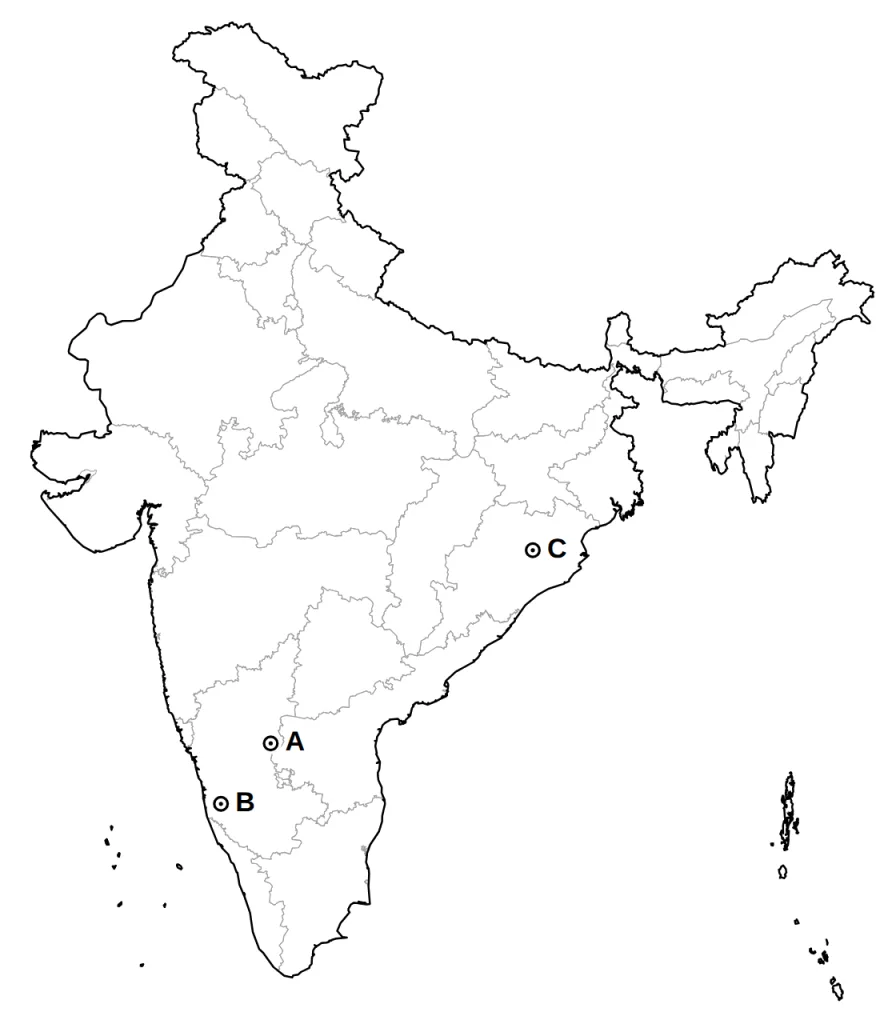
Question 4 (3 marks)
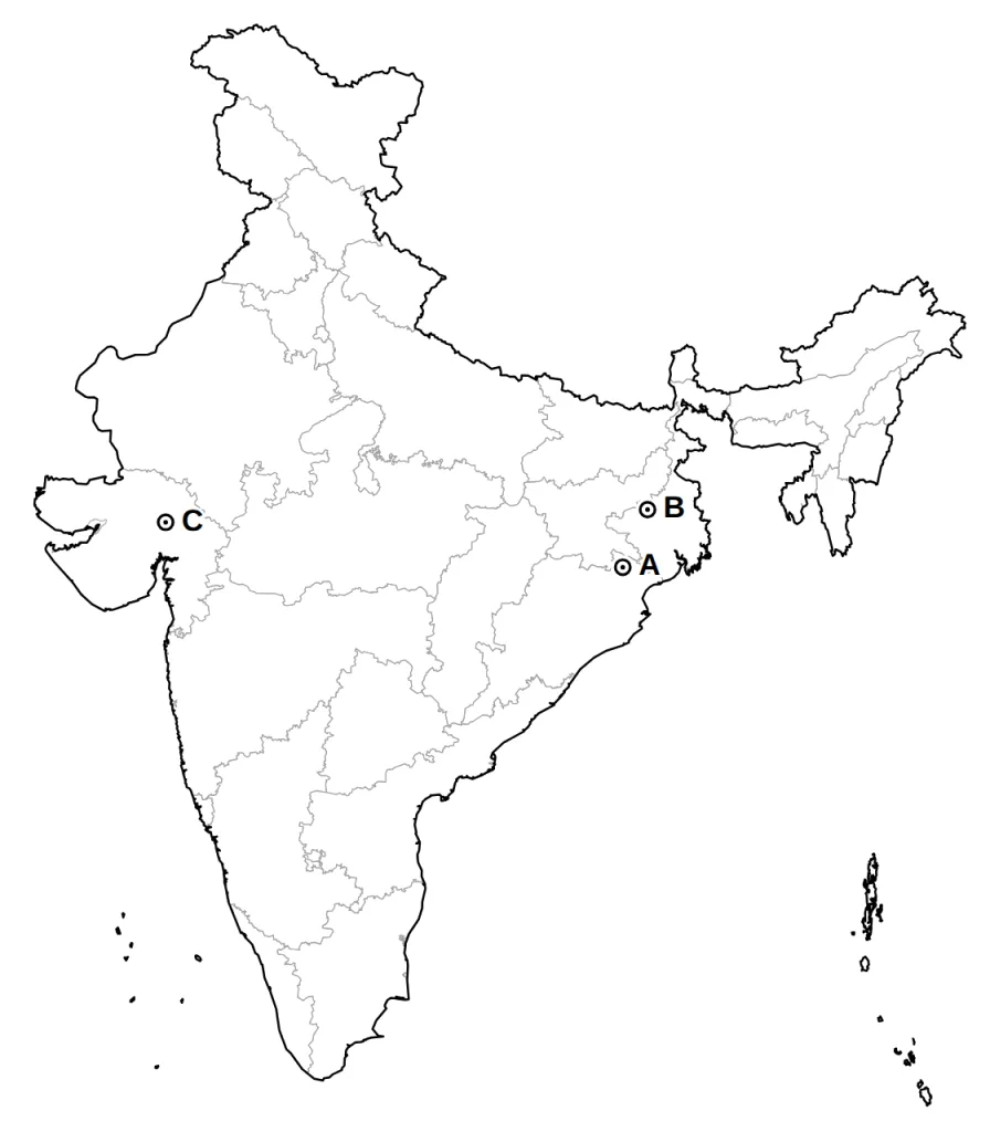
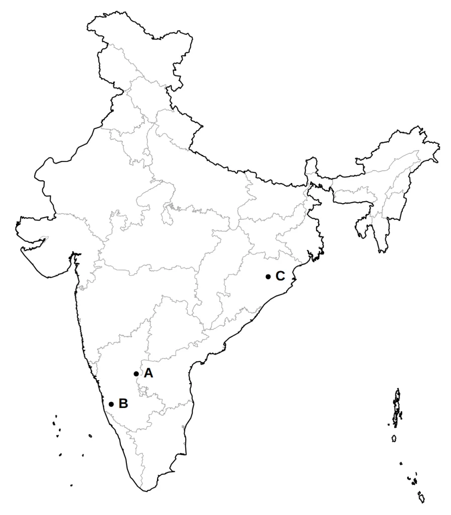
Three places A, B and C are marked on the outline map of India given below. Identify them with the help of the following information and write their correct names.
A. An iron ore mine in the interior of northern Karnataka.
B. An iron ore mine high in the Western Ghats of Karnataka, not far inland from the Mangaluru coast.
C. A coal field in the interior of Odisha.
Answer.
Model answer:
A. Bellary: the interior of northern Karnataka.
B. Kudremukh: the Western Ghats of Karnataka, inland from the Mangaluru coast.
C. Talcher: central Odisha, north-west of Cuttack.
Marking scheme:
- A: Bellary — 1 mark
- B: Kudremukh — 1 mark
- C: Talcher — 1 mark
Question 5 (3 marks)
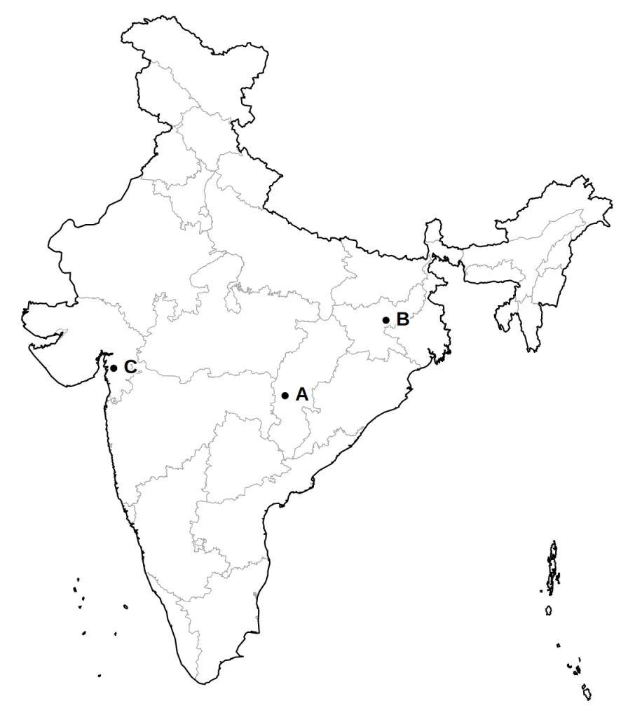
Three places A, B and C are marked on the outline map of India given below. Identify them with the help of the following information and write their correct names.
A. An iron ore mine in Chhattisgarh that supplies ore to the steel plant at Bhilai.
B. A coal mine in Jharkhand that shares its name with a steel plant.
C. An oil field of south Gujarat, near Bharuch.
Answer.
Model answer:
A. Durg: Chhattisgarh, south-west of Raipur.
B. Bokaro: the Damodar valley, Jharkhand.
C. Ankaleshwar (Ankleshwar): south Gujarat, near Bharuch on the Narmada.
Marking scheme:
- A: Durg — 1 mark
- B: Bokaro — 1 mark
- C: Ankaleshwar (Ankleshwar) — 1 mark
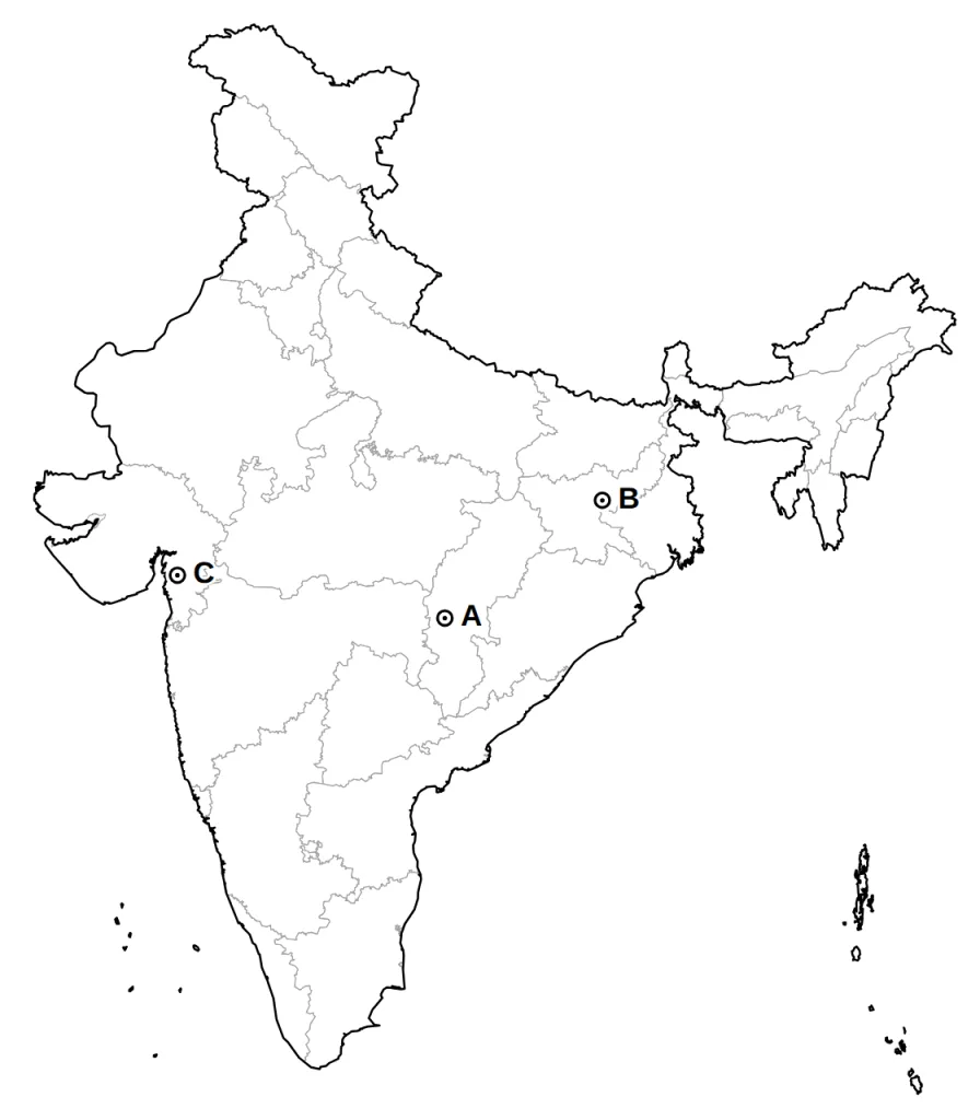
Question 6 (3 marks)
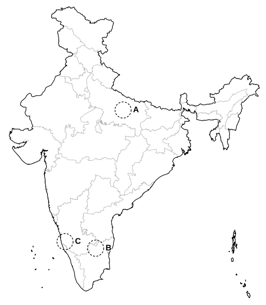
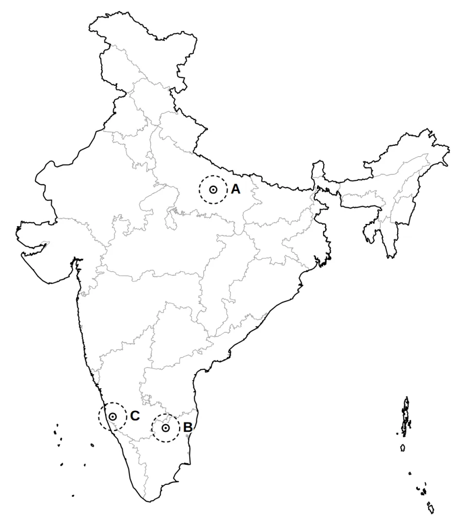
Three areas A, B and C are ringed on the outline map of India given below. Identify the soil type that covers most of each area.
Answer.
Model answer:
A. Alluvial soil: the Ganga plain of central Uttar Pradesh, laid down by the Himalayan rivers.
B. Red and yellow soil: the eastern side of the southern plateau, formed on crystalline igneous rocks in areas of low rainfall.
C. Laterite soil: the Western Ghats and coast of Karnataka, where high heat and heavy rain wash out the nutrients.
Marking scheme:
- A: alluvial soil — 1 mark
- B: red and yellow soil — 1 mark
- C: laterite soil — 1 mark
Question 7 (3 marks)
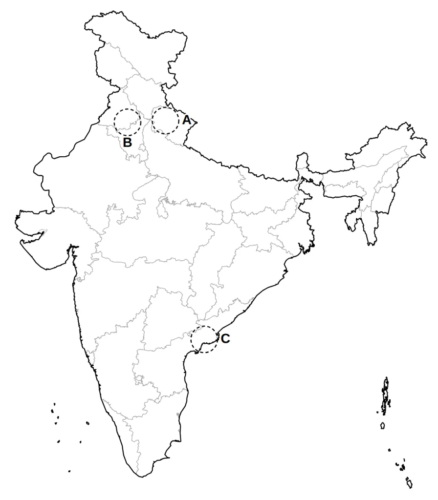
Three areas A, B and C are ringed on the outline map of India given below. Identify:
A. the soil type that covers most of area A;
B. the main food crop of area B, sown in winter with the help of irrigation;
C. the main food crop of area C, a kharif crop that needs high temperature and heavy rain.
Answer.
Model answer:
A. Forest soil: the Himalayan slopes of Uttarakhand.
B. Wheat: the Punjab plain, part of the Ganga-Satluj plains; a rabi crop.
C. Rice: the Godavari-Krishna delta of coastal Andhra Pradesh; a kharif crop.
Marking scheme:
- A: forest soil (mountain soil is also accepted) — 1 mark
- B: wheat — 1 mark
- C: rice — 1 mark
Question 8 (3 marks)
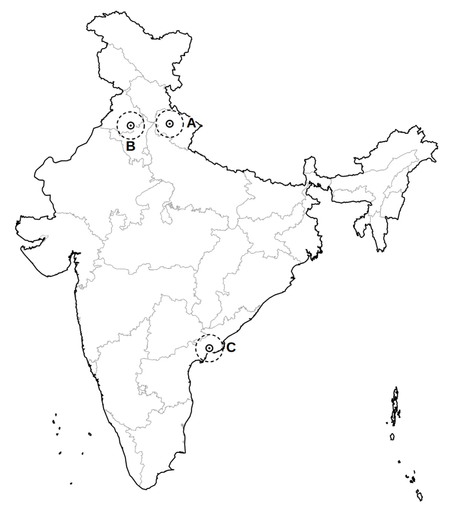
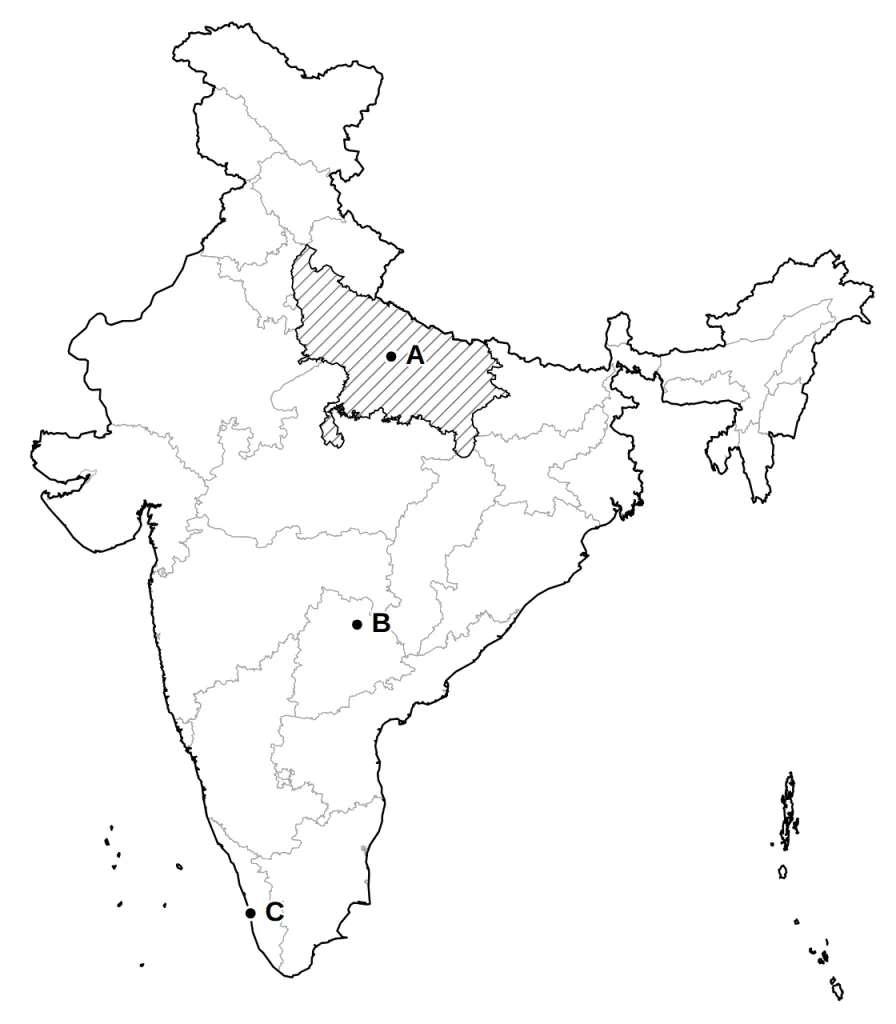
Three places A, B and C are marked on the outline map of India given below. Identify them with the help of the following information and write their correct names.
A. The state shaded on the map, which produces the most sugarcane in India.
B. A thermal power plant close to the Godavari, in the north of Telangana.
C. A major sea port on the Kerala coast.
Answer.
Model answer:
A. Uttar Pradesh: the largest producer of sugarcane.
B. Ramagundam: thermal, northern Telangana, on the Godavari.
C. Kochi: port, central Kerala coast.
Marking scheme:
- A: Uttar Pradesh — 1 mark
- B: Ramagundam — 1 mark
- C: Kochi — 1 mark
Question 9 (3 marks)
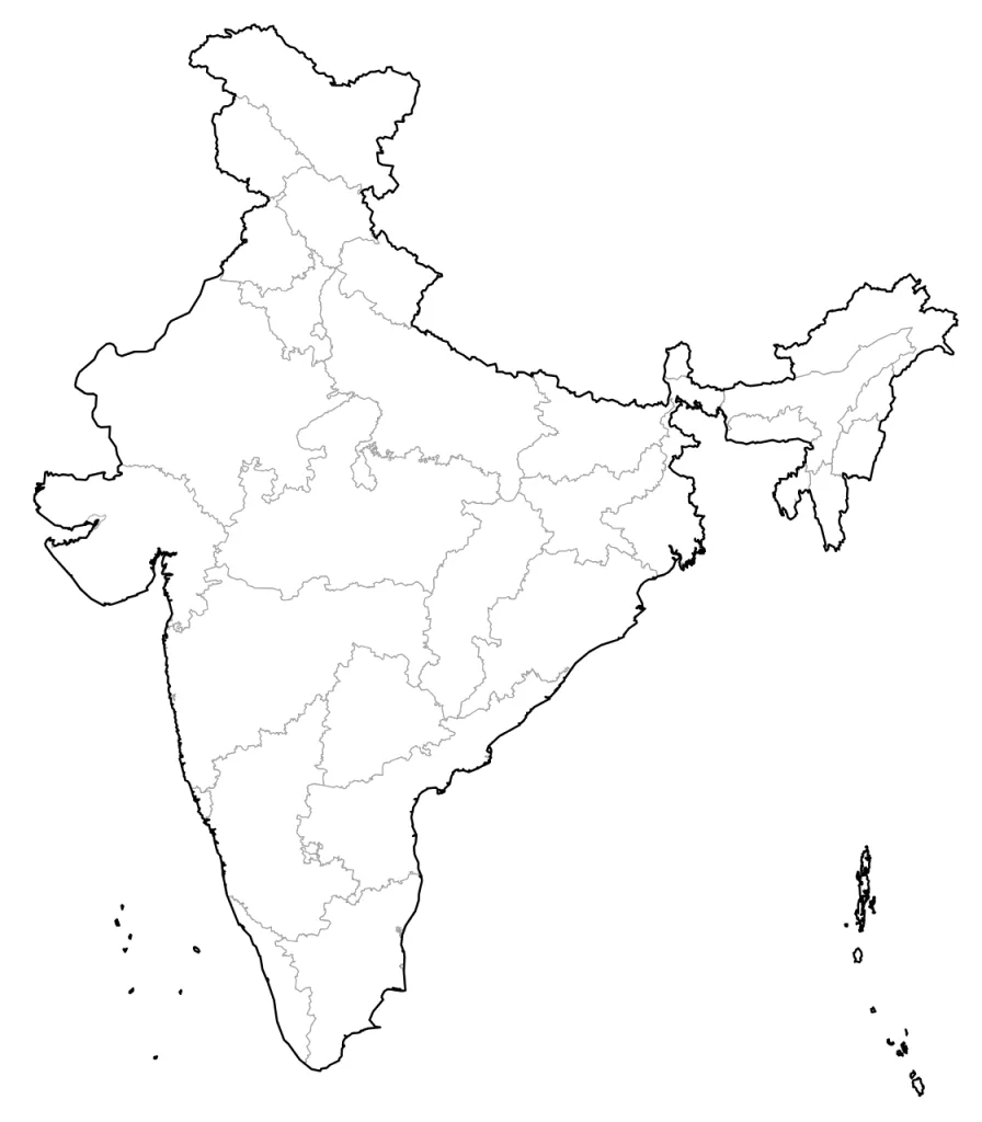
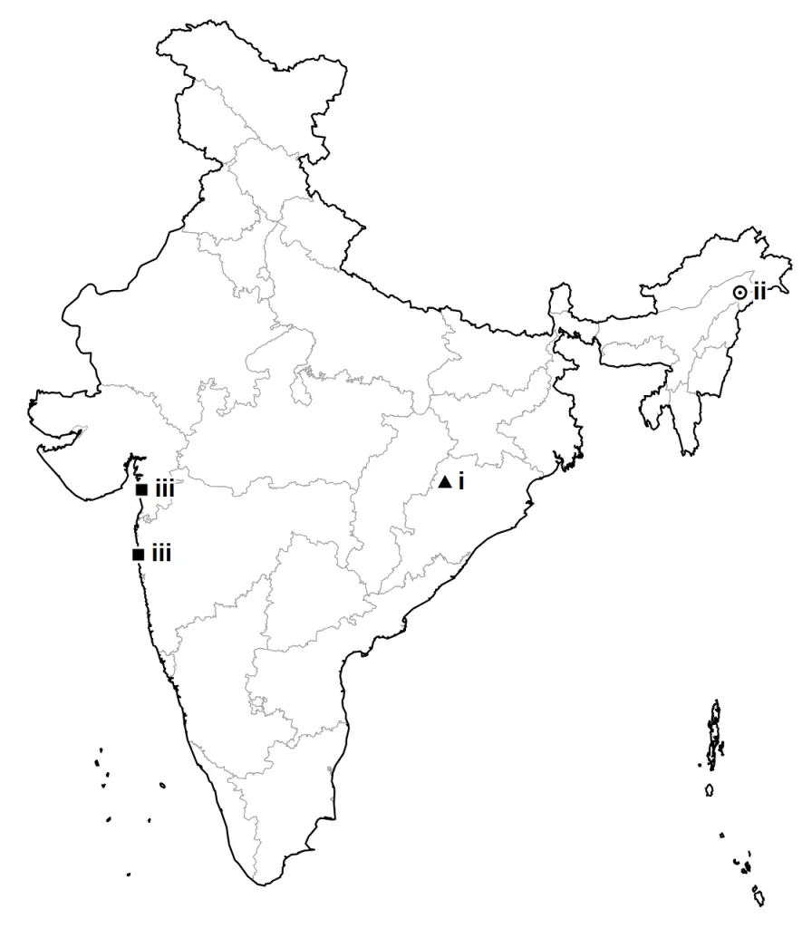
On the outline map of India given below, locate and label any three of the following with suitable symbols.
(i) An international airport close to India's border with Pakistan from your map list
(ii) A nuclear power plant on the Tamil Nadu coast, south of Chennai
(iii) The dam in Gujarat from your map list
(iv) A cotton textile centre in Tamil Nadu from your map list
Answer.
Model answer:
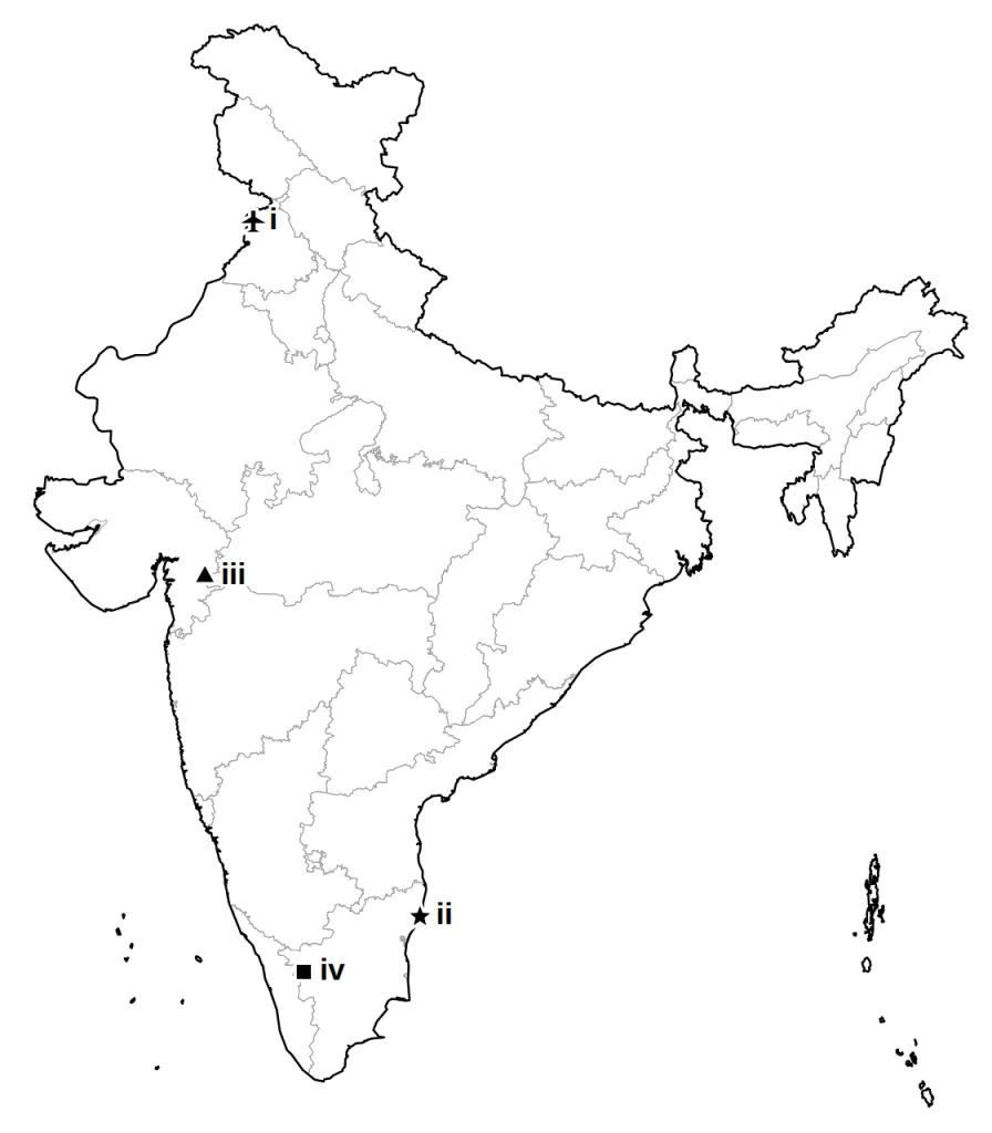
(i) Sri Guru Ram Das Jee (Raja Sansi) International Airport, Amritsar: Punjab, in the north-west.
(ii) Kalpakkam: nuclear, on the Tamil Nadu coast, south of Chennai.
(iii) Sardar Sarovar Dam: on the Narmada, south-eastern Gujarat.
(iv) Coimbatore: cotton textiles, western Tamil Nadu, near Kerala.
Mark any three; the answer map shows all four.
Marking scheme:
- First place chosen: symbol at the right spot and its name — 1 mark
- Second place chosen: symbol at the right spot and its name — 1 mark
- Third place chosen: symbol at the right spot and its name — 1 mark
Question 10 (3 marks)
On the outline map of India given below, locate and label any three of the following with suitable symbols.
(i) A Software Technology Park on the east coast of India from your map list
(ii) A nuclear power plant in Uttar Pradesh from your map list
(iii) A cotton textile centre in Madhya Pradesh from your map list
(iv) A major sea port on the Gulf of Kachchh
Answer.
Model answer:
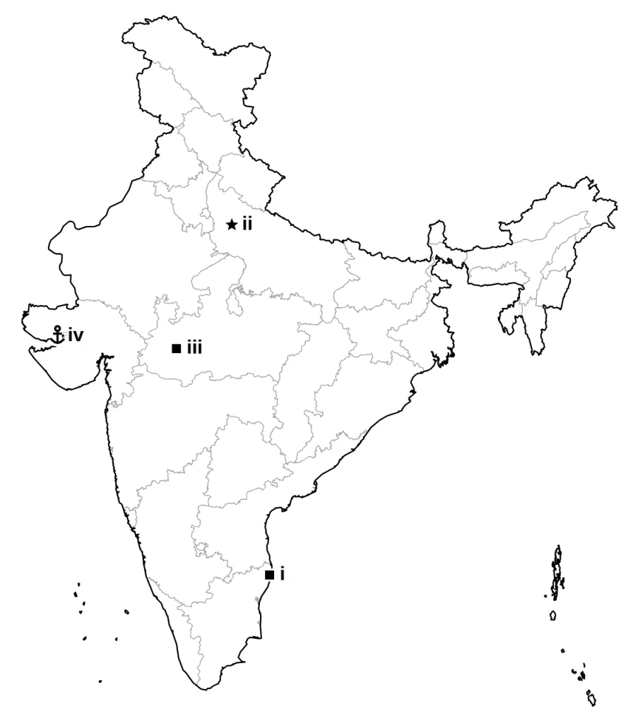
(i) Chennai: software park, east coast, Tamil Nadu.
(ii) Narora: nuclear, western Uttar Pradesh, on the Ganga.
(iii) Indore: cotton textiles, western Madhya Pradesh.
(iv) Kandla: port, at the head of the Gulf of Kachchh, Gujarat.
Mark any three; the answer map shows all four.
Marking scheme:
- First place chosen: symbol at the right spot and its name — 1 mark
- Second place chosen: symbol at the right spot and its name — 1 mark
- Third place chosen: symbol at the right spot and its name — 1 mark
Question 11 (3 marks)
On the outline map of India given below, locate and label any three of the following with suitable symbols.
(i) An oil field in the Arabian Sea off Maharashtra, nearer the shore than Mumbai High
(ii) An international airport in West Bengal from your map list
(iii) Salem, an iron and steel plant
(iv) A Software Technology Park in Gujarat from your map list
Answer.
Model answer:
(i) Bassein: in the Arabian Sea, west of Mumbai, nearer the shore than Mumbai High.
(ii) Netaji Subhash Chandra Bose International Airport, Kolkata: West Bengal, in the east.
(iii) Salem: iron and steel, interior of Tamil Nadu.
(iv) Gandhinagar: software park, capital of Gujarat, next to Ahmedabad.
Mark any three; the answer map shows all four.
Marking scheme:
- First place chosen: symbol at the right spot and its name — 1 mark
- Second place chosen: symbol at the right spot and its name — 1 mark
- Third place chosen: symbol at the right spot and its name — 1 mark
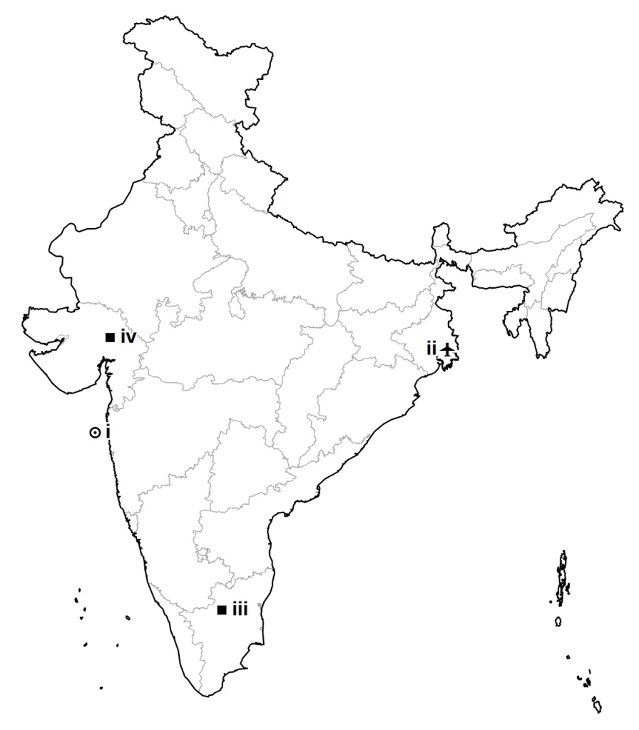
Question 12 (3 marks)
On the outline map of India given below, locate and label any three of the following with suitable symbols.
(i) The major sea port of Maharashtra from your map list
(ii) The state that grows the most tea in India
(iii) The dam on the Telangana-Andhra Pradesh border from your map list
(iv) Bokaro, an iron and steel plant
Answer.
Model answer:
(i) Mumbai: port, west coast, Maharashtra.
(ii) Assam: the largest producer of tea.
(iii) Nagarjuna Sagar Dam: on the Krishna, on the Telangana-Andhra Pradesh border.
(iv) Bokaro: iron and steel, Jharkhand, Damodar valley.
Mark any three; the answer map shows all four.
Marking scheme:
- First place chosen: symbol at the right spot and its name — 1 mark
- Second place chosen: symbol at the right spot and its name — 1 mark
- Third place chosen: symbol at the right spot and its name — 1 mark
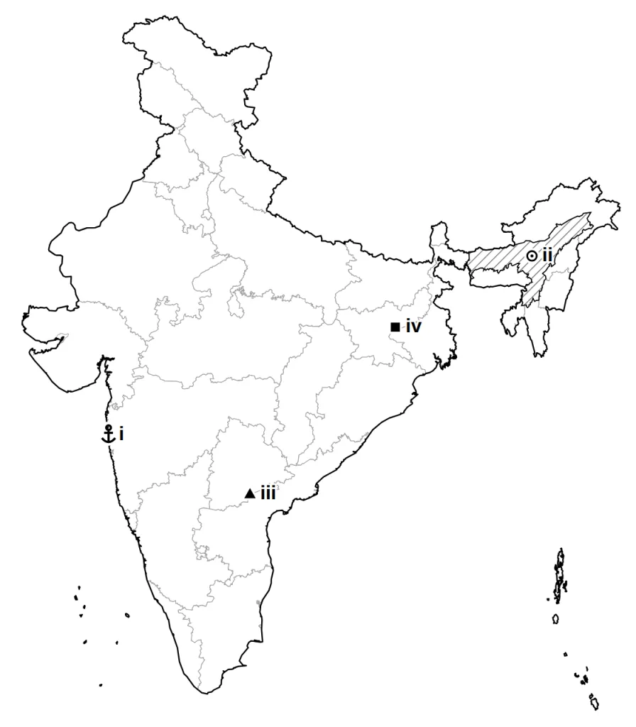
Question 13 (3 marks)
On the outline map of India given below, locate and label the following with suitable symbols. Where two places are joined by OR, do only one of them.
(i) Noida Software Technology Park OR Bengaluru Software Technology Park
(ii) Chennai Port OR Tuticorin Port
(iii) Chhatrapati Shivaji International Airport
Answer.
Model answer:
(i) Noida: software park, Uttar Pradesh, next to Delhi OR Bengaluru: software park, south-eastern Karnataka, on the plateau.
(ii) Chennai: port, east coast, Tamil Nadu OR Tuticorin: port, south-east coast of Tamil Nadu.
(iii) Chhatrapati Shivaji International Airport, Mumbai: Maharashtra, west coast.
Marking scheme:
- (i) Noida or Bengaluru, marked at the right place with a symbol and named — 1 mark
- (ii) Chennai or Tuticorin, marked at the right place with a symbol and named — 1 mark
- (iii) Chhatrapati Shivaji International Airport, Mumbai, marked at the right place with a symbol and named — 1 mark
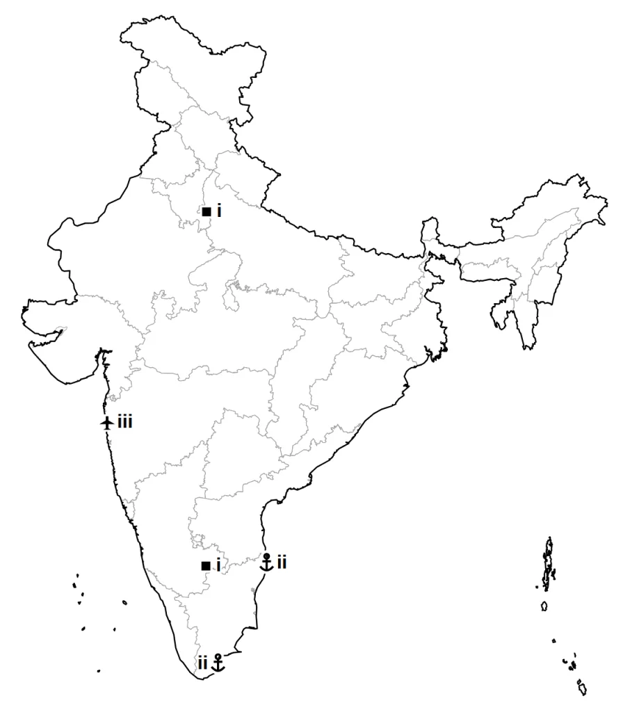
Question 14 (3 marks)
On the outline map of India given below, locate and label the following with suitable symbols. Where two places are joined by OR, do only one of them.
(i) The largest cotton-producing state OR The largest jute-producing state
(ii) Indira Gandhi International Airport OR Meenambakkam International Airport
(iii) Mumbai, a Software Technology Park
Answer.
Model answer:
(i) Gujarat or Maharashtra: black-soil states; either is accepted, both shown as i OR West Bengal: the largest producer of jute, in the Ganga-Brahmaputra delta.
(ii) Indira Gandhi International Airport, Delhi: in the national capital, in the north of India OR Meenambakkam International Airport, Chennai: Tamil Nadu, east coast.
(iii) Mumbai: software park, west coast, Maharashtra.
Marking scheme:
- (i) Gujarat or Maharashtra or West Bengal, marked at the right place with a symbol and named — 1 mark
- (ii) Indira Gandhi International Airport, Delhi or Meenambakkam International Airport, Chennai, marked at the right place with a symbol and named — 1 mark
- (iii) Mumbai, marked at the right place with a symbol and named — 1 mark
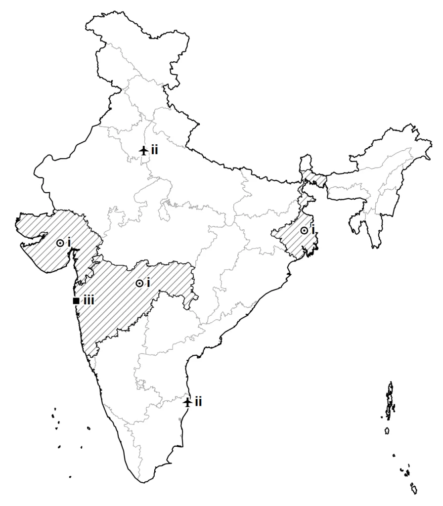
Question 15 (3 marks)
On the outline map of India given below, locate and label the following with suitable symbols. Where two places are joined by OR, do only one of them.
(i) Hirakud Dam
(ii) Naharkatia oil field
(iii) Surat, a cotton textile centre OR Mumbai, a cotton textile centre
Answer.
Model answer:
(i) Hirakud Dam: on the Mahanadi, near Sambalpur, western Odisha.
(ii) Naharkatia: upper Assam, close to Digboi.
(iii) Surat: cotton textiles, south Gujarat, at the mouth of the Tapi OR Mumbai: cotton textiles, on the west coast, Maharashtra.
Marking scheme:
- (i) Hirakud Dam, marked at the right place with a symbol and named — 1 mark
- (ii) Naharkatia, marked at the right place with a symbol and named — 1 mark
- (iii) Surat or Mumbai, marked at the right place with a symbol and named — 1 mark
Long Answer and Case-Based Questions
Question 16 (5 marks)
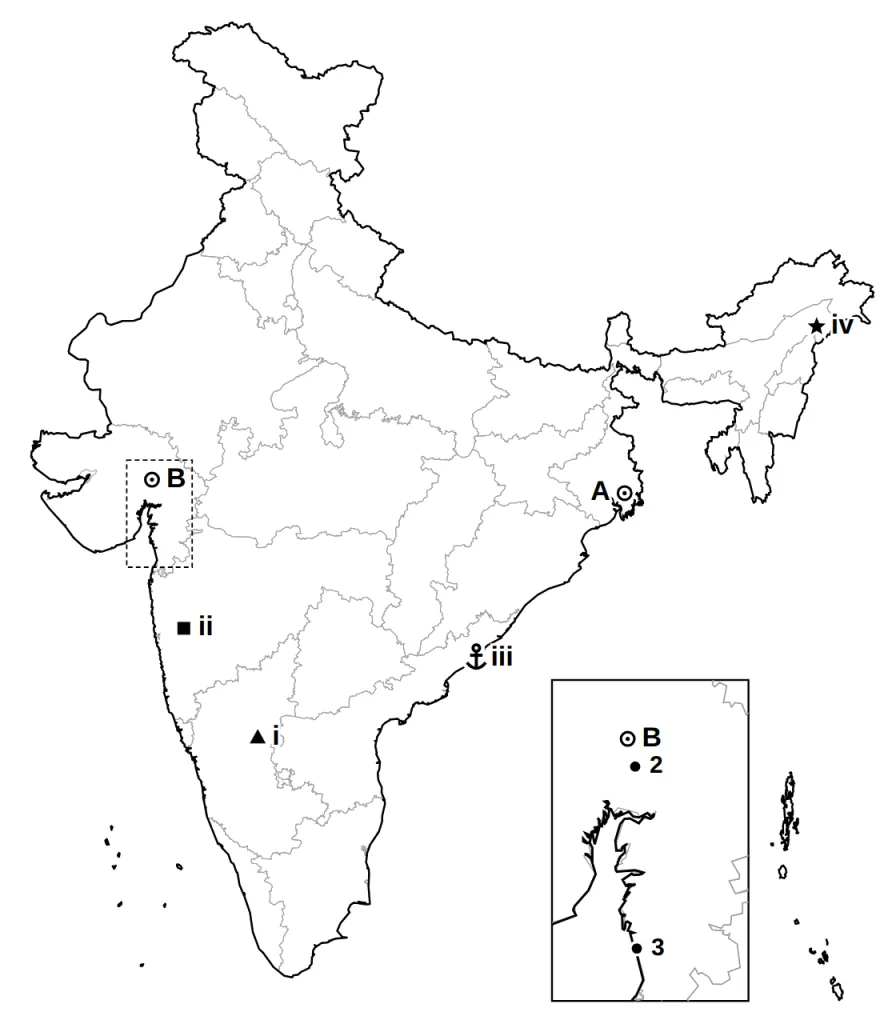
Answer both parts on the outline map of India given below.
(a) Q9-style (History, 2 marks): two places are marked A and B on the map. Identify them with the help of the information given and write their correct names near them.
(b) Q19-style (Geography, 3 marks): on the same map, locate and label any three of the four places listed in (b) with suitable symbols.
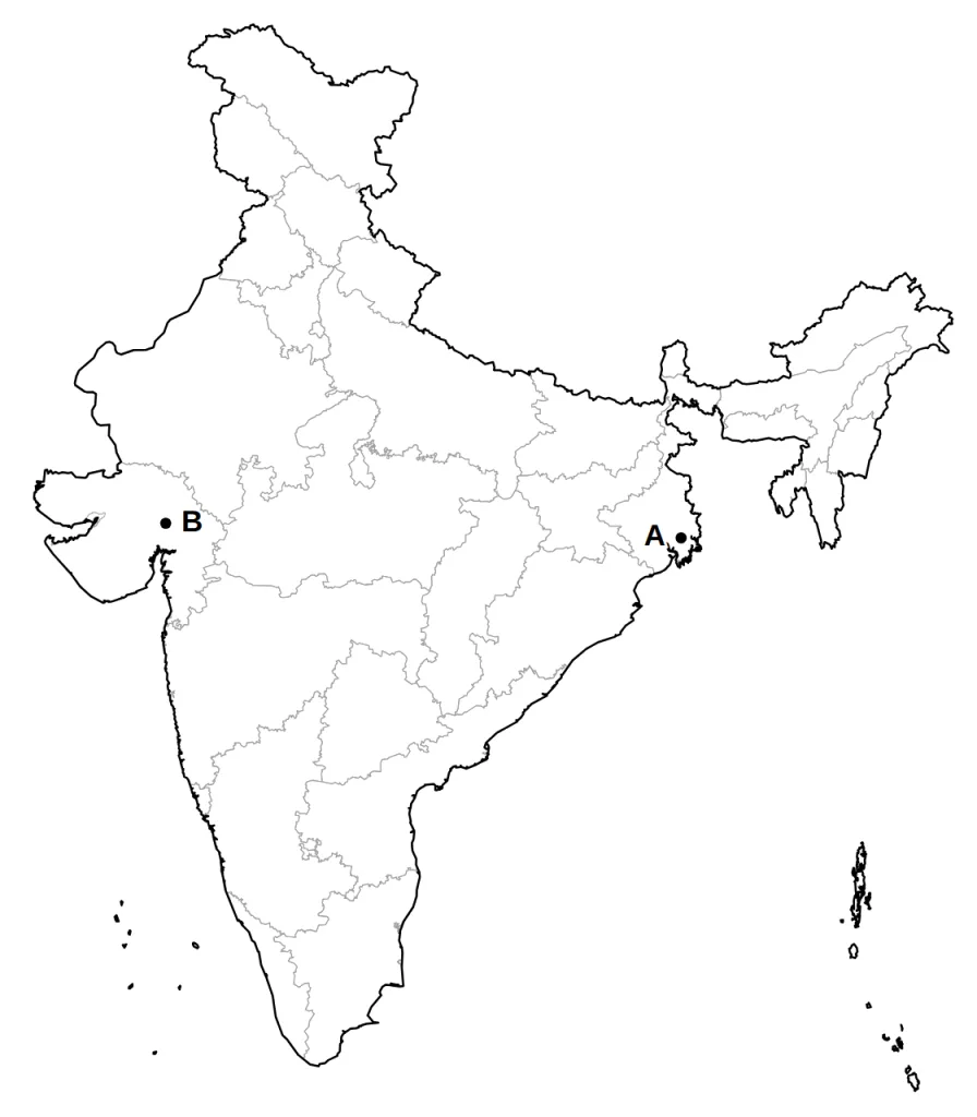
A The capital of the old Bengal Presidency, where Gandhiji first won the Congress over to non-cooperation at a special session. (1 mark)
Answer.
- Calcutta (now Kolkata): West Bengal, in the east, on the Hooghly near the Bay of Bengal — 1 mark
B The city from whose Sabarmati Ashram Gandhiji and his volunteers set out on foot in March 1930. (1 mark)
Answer.
Model answer:
In the zoomed box, B is Ahmedabad; 2 is Kheda and 3 is Dandi, the other Gujarat places on the list.
Marking scheme:
- Ahmedabad: Gujarat, inland, on the Sabarmati — 1 mark
(b) Any three of these:
(i) The dam in Karnataka from your map list
(ii) A Software Technology Park on the Deccan plateau in Maharashtra
(iii) A major sea port in Andhra Pradesh from your map list
(iv) A thermal power plant in the Brahmaputra valley from your map list (3 marks)
Answer.
Model answer:
(i) Tungabhadra Dam: on the Tungabhadra river, near Hosapete, Karnataka.
(ii) Pune: software park, Maharashtra, inland, south-east of Mumbai.
(iii) Visakhapatnam: port, Andhra Pradesh coast.
(iv) Namrup: thermal, upper Assam.
Mark any three; the answer map shows all four.
Marking scheme:
- First place chosen: symbol at the right spot and its name — 1 mark
- Second place chosen: symbol at the right spot and its name — 1 mark
- Third place chosen: symbol at the right spot and its name — 1 mark
Question 17 (5 marks)
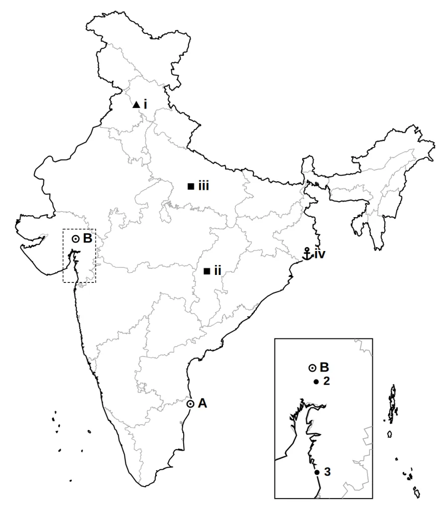
Answer both parts on the outline map of India given below.
(a) Q9-style (History, 2 marks): two places are marked A and B on the map. Identify them with the help of the information given and write their correct names near them.
(b) Q19-style (Geography, 3 marks): on the same map, locate and label any three of the four places listed in (b) with suitable symbols.
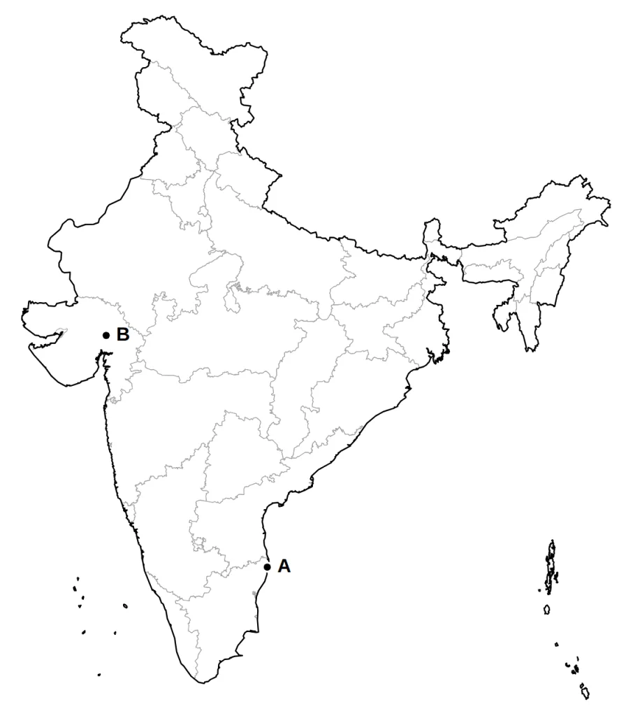
A The capital of the presidency where the Justice Party, which spoke for non-Brahman groups, chose to contest the council elections instead of boycotting them. The Congress met here in 1927. (1 mark)
Answer.
- Madras (now Chennai): Tamil Nadu, on the east coast — 1 mark
B The Gujarat city where Gandhiji took the side of textile mill workers in a dispute over their wages in 1918. (1 mark)
Answer.
Model answer:
In the zoomed box, B is Ahmedabad; 2 is Kheda and 3 is Dandi, the other Gujarat places on the list.
Marking scheme:
- Ahmedabad: Gujarat, inland, on the Sabarmati — 1 mark
(b) Any three of these:
(i) The dam on the Satluj from your map list
(ii) An iron and steel plant in Chhattisgarh from your map list
(iii) A cotton textile centre in Uttar Pradesh from your map list
(iv) A major sea port in West Bengal from your map list (3 marks)
Answer.
Model answer:
(i) Bhakra Nangal Dam: on the Satluj, at the Himachal Pradesh-Punjab border.
(ii) Bhilai: iron and steel, Chhattisgarh, near Raipur.
(iii) Kanpur: cotton textiles, Uttar Pradesh, on the Ganga.
(iv) Haldia: port, West Bengal, near the mouth of the Hooghly, south-west of Kolkata.
Mark any three; the answer map shows all four.
Marking scheme:
- First place chosen: symbol at the right spot and its name — 1 mark
- Second place chosen: symbol at the right spot and its name — 1 mark
- Third place chosen: symbol at the right spot and its name — 1 mark
Question 18 (5 marks)
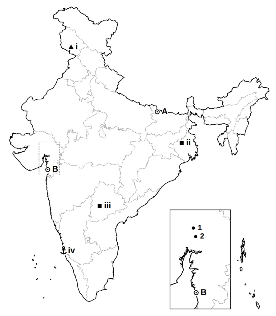
Answer both parts on the outline map of India given below.
(a) Q9-style (History, 2 marks): two places are marked A and B on the map. Identify them with the help of the information given and write their correct names near them.
(b) Q19-style (Geography, 3 marks): on the same map, locate and label any three of the four places listed in (b) with suitable symbols.
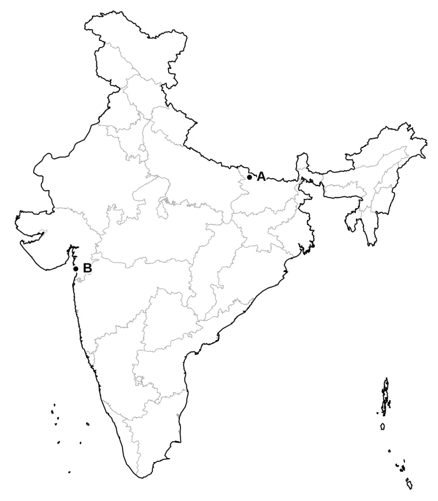
A The place in Bihar where the oppression of peasants by indigo planters brought Gandhiji in 1917. (1 mark)
Answer.
- Champaran: Bihar, in its north-west corner, along the Nepal border — 1 mark
B The place that gave its name to the march Gandhiji began from his Sabarmati ashram in March 1930. (1 mark)
Answer.
Model answer:
In the zoomed box, B is Dandi; 1 is Ahmedabad and 2 is Kheda, the other Gujarat places on the list.
Marking scheme:
- Dandi: Gujarat, on the coast, south of Surat — 1 mark
(b) Any three of these:
(i) A dam in Jammu and Kashmir from your map list
(ii) An iron and steel plant in West Bengal from your map list
(iii) A Software Technology Park in Telangana from your map list
(iv) A major sea port in Karnataka from your map list (3 marks)
Answer.
Model answer:
(i) Salal Dam: on the Chenab, Jammu and Kashmir.
(ii) Durgapur: iron and steel, western West Bengal.
(iii) Hyderabad: software park, the middle of Telangana.
(iv) New Mangalore: port, Karnataka coast.
Mark any three; the answer map shows all four.
Marking scheme:
- First place chosen: symbol at the right spot and its name — 1 mark
- Second place chosen: symbol at the right spot and its name — 1 mark
- Third place chosen: symbol at the right spot and its name — 1 mark
Question 19 (5 marks)
Answer both parts on the outline map of India given below.
(a) Q9-style (History, 2 marks): two places are marked A and B on the map. Identify them with the help of the information given and write their correct names near them.
(b) Q19-style (Geography, 3 marks): on the same map, locate and label any three of the four places listed in (b) with suitable symbols.
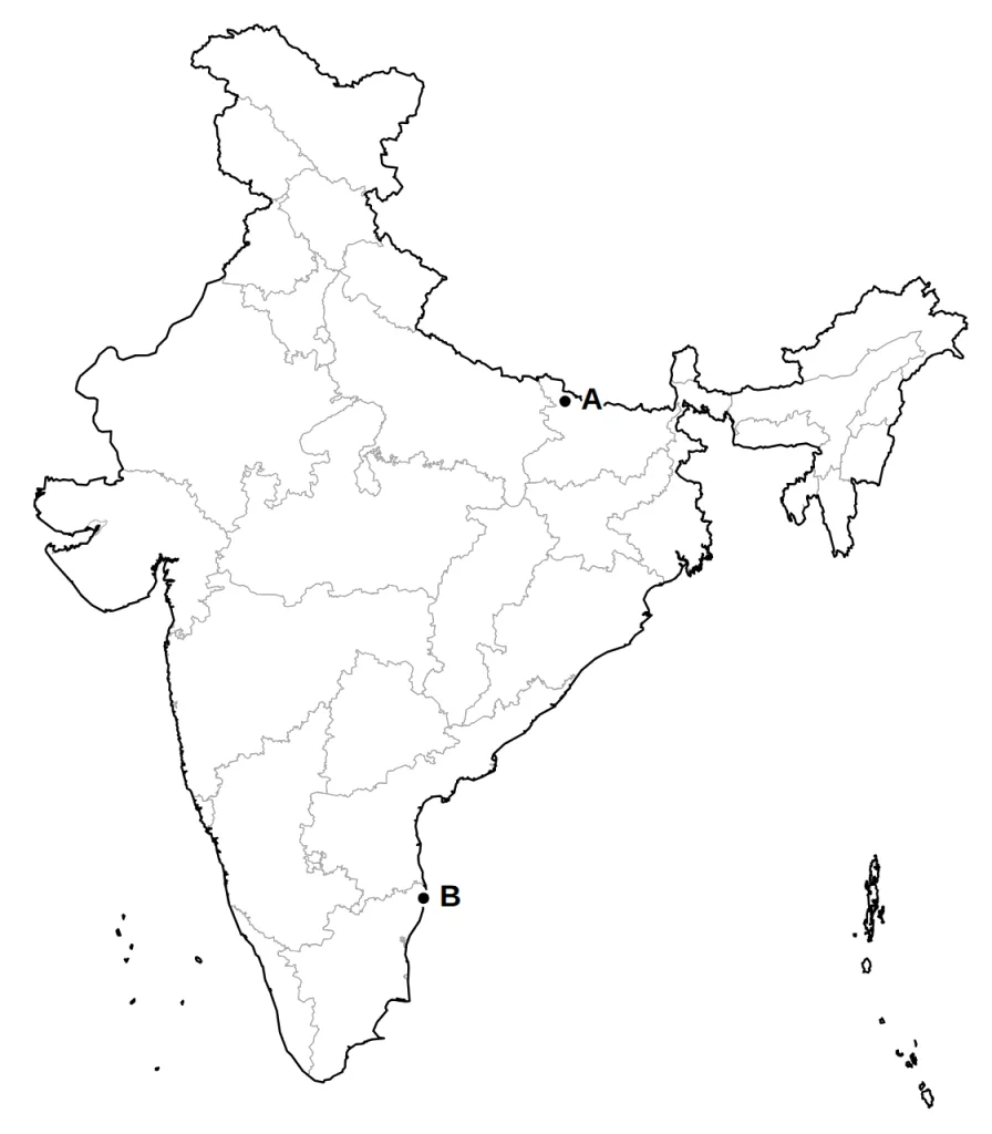
A The district along the Nepal border where Gandhiji's first satyagraha in India took the side of peasants forced to grow indigo. (1 mark)
Answer.
- Champaran: Bihar, in its north-west corner, along the Nepal border — 1 mark
B The port city of the south-east coast where the Congress met in 1927. (1 mark)
Answer.
- Madras (now Chennai): Tamil Nadu, on the east coast — 1 mark
(b) Any three of these:
(i) The dam in Rajasthan from your map list
(ii) Jamshedpur, an iron and steel plant
(iii) A nuclear power plant on the coast north of Mumbai
(iv) A major sea port in Goa from your map list (3 marks)
Answer.
Model answer:
(i) Rana Pratap Sagar Dam: on the Chambal, south-eastern Rajasthan.
(ii) Jamshedpur: iron and steel, south-eastern Jharkhand.
(iii) Tarapur: nuclear, on the Maharashtra coast, north of Mumbai.
(iv) Marmagao: port, coast of Goa.
Mark any three; the answer map shows all four.
Marking scheme:
- First place chosen: symbol at the right spot and its name — 1 mark
- Second place chosen: symbol at the right spot and its name — 1 mark
- Third place chosen: symbol at the right spot and its name — 1 mark