
Water Resources
Water Resources carried 3 marks in the 2026-27 sample paper, 5 in February 2026 and 4 in May 2026. It gave the Geography source-based question in both 2026 papers (the Sardar Sarovar Project; the water demand of industries and cities), the 2-marker in the sample paper (traditional rainwater harvesting for a drought-prone district), and MCQs such as dam-and-river matching and the Krishna-Godavari dispute in 2025. A dam from the list of eight is often one of the map items.
Marks are most often lost on the map (Salal and Salem, Rana Pratap Sagar and Sardar Sarovar), by writing only "dams are good" or only "dams are bad" when the question wants both sides, and by mixing up the harvesting methods and their regions.
Revise in 5 Minutes
Water scarcity
- About three-fourths of the Earth is water, but only a small part is usable fresh water, renewed by the hydrological cycle.
- Causes: over-use and unequal access; growing population; irrigation and dry-season crops with private wells and tubewells; industries (water plus hydel power); cities and housing societies pumping groundwater; pollution.
- Conserve to avoid health hazards, keep food security and livelihoods, and protect ecosystems.
Multipurpose projects: irrigation, power, water supply, flood control, recreation, navigation, fish breeding. Bhakra Nangal: hydel power + irrigation. Hirakud: water conservation + flood control. Nehru: "temples of modern India".
Problems of dams: poor sediment flow and silt in the reservoir; rivers fragmented; flood plains submerged; displacement (Narmada Bachao Andolan, Tehri Dam Andolan); water-intensive crops and salinity; rich-poor gap; inter-state disputes (Krishna-Godavari over Koyna); floods (2006, Maharashtra and Gujarat); earthquakes, water-borne diseases, pollution.
Past water structures: Chandragupta Maurya's dams and lakes; Sringaverapura (1st century BCE); Kalinga, Nagarjunakonda, Bennur, Kolhapur; Bhopal Lake (11th century); Hauz Khas tank (14th century).
Rainwater harvesting
| Method | Region |
|---|---|
| Guls, kuls | Western Himalaya |
| Rooftop harvesting, tankas | Rajasthan (Bikaner, Phalodi, Barmer) |
| Inundation channels | Flood plains of Bengal |
| Khadins, johads | Jaisalmer, other parts of Rajasthan |
| Bamboo drip irrigation (about 200 years old) | Meghalaya |
Tankas: first rain kept out; palar pani; declining with the Rajasthan Canal. Today: Tamil Nadu made rooftop harvesting compulsory; Shillong harvests despite Cherrapunji and Mawsynram nearby.
Dams on the map: Salal (Chenab, J&K), Bhakra Nangal (Satluj), Tehri (Bhagirathi, Uttarakhand), Rana Pratap Sagar (Chambal, Rajasthan), Sardar Sarovar (Narmada, Gujarat), Hirakud (Mahanadi, Odisha), Nagarjuna Sagar (Krishna, Telangana-AP), Tungabhadra (Karnataka).
Traps
- Hirakud is flood control; Bhakra Nangal is power and irrigation.
- Salal (dam, J&K) is not Salem (steel, Tamil Nadu).
- Dams have also caused floods.
How to use this page: try each question on paper first, then read the answer. The marks against each step show what an examiner looks for. The 1-mark MCQs and Assertion-Reason questions are in the quiz at the end, together with questions that test how well you understand the chapter; every quiz answer comes with its explanation.
Short Answer Questions (2 and 3 Marks)
Question 1 (3 marks)
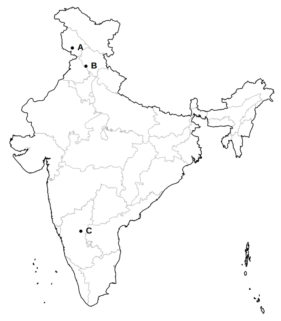
Three dams from your map list, A, B and C, are marked on the outline map of India given below. Identify them with the help of the following information and write their correct names.
A. The dam in Reasi district of Jammu and Kashmir, on the Chenab.
B. The dam on the Satluj, near the border of Himachal Pradesh and Punjab.
C. The dam near Hosapete in Karnataka, named after the river on which it stands.
Answer.
Model answer:
A. Salal dam, on the Chenab in Jammu and Kashmir.
B. Bhakra Nangal dam, on the Satluj near the Himachal Pradesh-Punjab border.
C. Tungabhadra dam, on the Tungabhadra near Hosapete in Karnataka.
Marking scheme:
- A: Salal (on the Chenab, Jammu and Kashmir) — 1 mark
- B: Bhakra Nangal (on the Satluj) — 1 mark
- C: Tungabhadra (on the Tungabhadra, Karnataka) — 1 mark
Question 2 (3 marks)
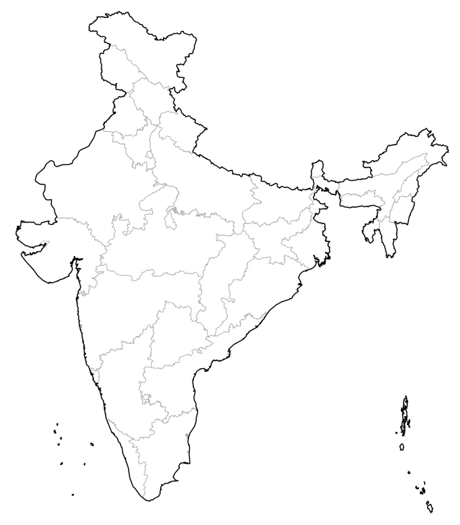
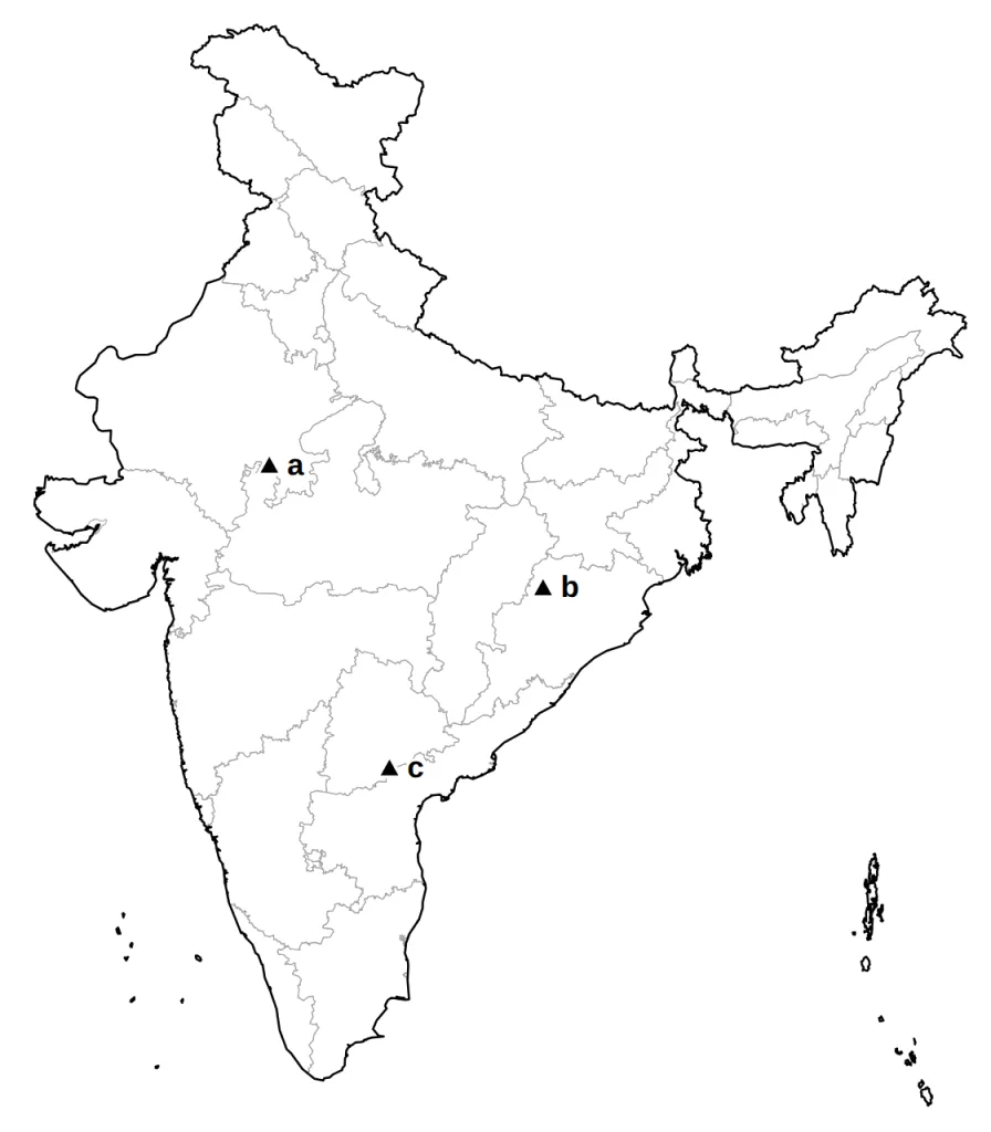
On the outline map of India given below, locate and label the following dams from your map list with suitable symbols.
(a) The dam on the Chambal in Rajasthan.
(b) The dam on the Mahanadi near Sambalpur in Odisha.
(c) The dam on the Krishna, on the border of Telangana and Andhra Pradesh.
Answer.
Model answer:
(a) Rana Pratap Sagar, on the Chambal in south-eastern Rajasthan.
(b) Hirakud, on the Mahanadi near Sambalpur in Odisha.
(c) Nagarjuna Sagar, on the Krishna, on the Telangana-Andhra Pradesh border.
The answer map shows them as a, b and c with triangles.
Marking scheme:
- (a) Rana Pratap Sagar, on the Chambal in south-eastern Rajasthan, located and labelled — 1 mark
- (b) Hirakud, on the Mahanadi near Sambalpur, Odisha, located and labelled — 1 mark
- (c) Nagarjuna Sagar, on the Krishna at the Telangana-Andhra Pradesh border, located and labelled — 1 mark
Question 3 (2 marks)
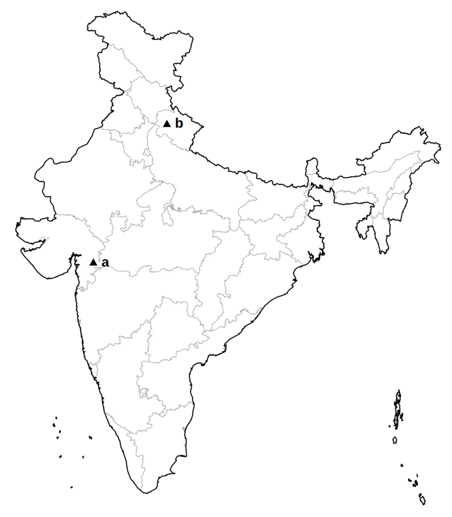
On the outline map of India given below, locate and label the following dams with suitable symbols.
(a) The dam on the Narmada in Gujarat against which the Narmada Bachao Andolan was organised.
(b) The dam on the Bhagirathi in Uttarakhand.
Answer.
Model answer:
(a) Sardar Sarovar, on the Narmada in Gujarat, near the Madhya Pradesh border.
(b) Tehri, on the Bhagirathi in the Garhwal hills of Uttarakhand.
The answer map shows them as a and b.
Marking scheme:
- (a) Sardar Sarovar, on the Narmada in Gujarat, located and labelled — 1 mark
- (b) Tehri, on the Bhagirathi in Uttarakhand, located and labelled — 1 mark
Question 4 (2 marks)
Three-fourths of the Earth's surface is covered with water, yet many regions face water scarcity. Explain.
Answer.
Model answer:
- Only a small part of all this water is fresh water that we can use.
- Where there is enough, over-use and unequal access among social groups still create scarcity.
Marking scheme:
- Only a small proportion of this water is fresh water that can be used. — 1 mark
- Even where fresh water is available, scarcity is caused by over-exploitation, excessive use and unequal access to water among different social groups. — 1 mark
Question 5 (3 marks)
Why do we need to conserve and manage our water resources? Give three reasons.
Answer.
Model answer:
- Clean, enough water protects us from diseases and other health hazards.
- Farming, industry and our livelihoods all run on water, so conserving it protects our food supply and jobs.
- Over-using water damages rivers, wetlands and the whole natural ecosystem.
Marking scheme:
- To safeguard ourselves from health hazards caused by polluted and scarce water. — 1 mark
- To keep up food security and the continuation of our livelihoods and productive activities. — 1 mark
- To prevent the degradation of our natural ecosystems; over-exploiting water impoverishes the resource and can cause an ecological crisis. — 1 mark
Question 6 (3 marks)
What is a multipurpose river project? After Independence, how were such projects expected to help farming and industry grow together?
Answer.
Model answer:
- A multipurpose project uses one river for many needs at once: irrigation, power, water supply, flood control, navigation and fish breeding.
- Its canals were to raise farm output and build up the village economy.
- Its power and water were to feed fast industrial and urban growth, so farms and factories would grow together.
Marking scheme:
- A river project that serves several purposes together, such as irrigation, electricity generation, water supply for homes and industries, flood control, recreation, inland navigation and fish breeding. — 1 mark
- Farming: canal water would raise farm output and develop the village economy. — 1 mark
- Industry: the same projects would give power and water for rapid industrialisation and the growth of cities, so both would grow together. — 1 mark
Question 7 (3 marks)
Explain three ways in which damming a river harms the river and the life in it.
Answer.
Model answer:
- Sediment is trapped in the reservoir, so the river bed below turns rocky and gives poor homes to water life.
- The river is cut into pieces, so fish cannot swim up or down to spawn.
- The reservoir drowns plants and soil on the flood plain, which rot over time.
Marking scheme:
- Sediment: the natural flow is disturbed, so too little sediment moves downstream and too much settles at the bottom of the reservoir; the stream bed below becomes rockier and a poorer home for water life. — 1 mark
- Fragmentation: dams break rivers into parts, so aquatic animals find it hard to migrate, especially for spawning. — 1 mark
- Submergence: reservoirs built on flood plains drown the existing vegetation and soil, which decompose over time. — 1 mark
Question 8 (3 marks)
In the dry west of Rajasthan, almost every traditional house once had a tanka. Why was the first spell of rain kept out of it, why was its water so valued, and why is the practice declining today?
Answer.
Model answer:
- The first rain was let go because it washes the dirt off the roof and pipes.
- Rainwater, called palar pani, was thought the purest water, and it lasted till the next rains, even when other sources dried up.
- Now the perennial Rajasthan Canal brings plenty of water, so fewer people harvest rain.
Marking scheme:
- The first spell of rain was not collected because it washes the dirt off the roof and the pipes. — 1 mark
- Rainwater, or palar pani, was thought to be the purest form of natural water, and the stored water lasted till the next rains, so it was a reliable source of drinking water in summer when other sources dried up. — 1 mark
- Today the perennial Rajasthan Canal brings plenty of water, so rooftop harvesting is declining (though some families keep their tankas because they do not like the taste of tap water). — 1 mark
Question 9 (3 marks)
How has assured canal irrigation from multipurpose projects changed farming and village society in some command areas? Explain three changes.
Answer.
Model answer:
- Farmers moved to water-hungry commercial crops.
- Heavy watering made the soil saline in many places.
- Richer landowners gained much more than the landless poor, so the gap between them grew.
Marking scheme:
- The cropping pattern changed: many farmers shifted to water-intensive and commercial crops. — 1 mark
- This had serious ecological effects, such as the salinisation of the soil. — 1 mark
- The social gap widened between the richer landowners and the landless poor. — 1 mark
Question 10 (2 marks)
Barmer and Jalore, desert districts of Rajasthan, are to get irrigation water from a dam built far away in Gujarat. Name the project, and explain why these districts need it.
Answer.
Model answer:
- The Sardar Sarovar Project on the Narmada, which serves four states.
- These desert districts are fully drought-prone, and assured canal water can make them drought-proof.
Marking scheme:
- The Sardar Sarovar Project on the Narmada, which covers four states: Gujarat, Madhya Pradesh, Maharashtra and Rajasthan. — 1 mark
- The whole of its command area in Rajasthan is drought-prone, so assured canal water can make it drought-proof. — 1 mark
Long Answer and Case-Based Questions
Question 11 (5 marks)
A district is short of water. One group wants a large multipurpose dam on the nearby river; another wants every village and town to harvest rainwater. Compare the two approaches on any five points.
Answer.
Model answer:
- Scale: a dam stores vast amounts of water for irrigation, power and industry across a region; harvesting works house by house and village by village.
- Reliability: a big reservoir can last through the dry months; a roof or field collects only the rain that falls on it.
- Cost: a dam needs huge money, engineers and years of work; harvesting is cheap and uses local skills.
- Land and people: a dam changes the whole river and may uproot villages; harvesting harms neither.
- Control: a dam is run from far away; harvesting is run by the people who use the water, a viable choice for people and the environment.
Marking scheme:
- Scale and uses: a big dam stores huge amounts of water for irrigation, power, industry and flood control over a whole region; rainwater harvesting works at the level of a house, field or village. — 1 mark
- Reliability: a large reservoir can carry water through the dry months for many districts; harvested rain is limited to what falls on one roof or field and may run short in a long dry spell. — 1 mark
- Cost and skills: a dam needs a huge investment, engineers and many years to build; rainwater harvesting is cheap and quick and uses local materials and traditional knowledge. — 1 mark
- Effect on the land and people: a big dam changes the whole river and may uproot villages; rainwater harvesting disturbs neither the river nor the people. — 1 mark
- Control: a dam is run by distant authorities; harvesting is managed by the families and villages that use the water, which is why many see it as a viable alternative, both socio-economically and environmentally. — 1 mark
OR
'Multipurpose river projects have brought India great gains, but at a price.' Explain two gains and three problems of these projects.
Answer.
Model answer:
- Irrigation: canals bring water to fields, so more crops can be grown.
- Power and more: they produce hydroelectricity and supply water to homes and industries.
- Displacement: thousands of families lose their land and livelihood when the reservoir fills.
- Disputes: states quarrel over sharing the water, costs and benefits.
- Health and land: such projects have been linked to earthquakes, water-borne diseases and pests, and pollution from over-use of water.
Marking scheme:
- Gain: irrigation for agriculture, so more crops can be grown. — 1 mark
- Gain: hydroelectric power, water supply for homes and industries, flood control, inland navigation, recreation or fish breeding (any one). — 1 mark
- Problem: large-scale displacement of local communities, who lose their land and livelihood. — 1 mark
- Problem: disputes between states over sharing the costs and benefits of a project. — 1 mark
- Problem: induced earthquakes, water-borne diseases and pests, and pollution from the excessive use of water (any one). — 1 mark
Question 12 (5 marks)
Each region of India shaped its own way of harvesting water to suit its land. For each region below, name the traditional method used and the problem of the land it solved.
(i) The mountains of the western Himalaya
(ii) The flood plains of Bengal
(iii) The dry fields of Jaisalmer and other parts of Rajasthan
(iv) Desert homes in Bikaner, Phalodi and Barmer
(v) The hill slopes of Meghalaya
Answer.
Model answer:
- Western Himalaya (steep slopes): guls or kuls diverted stream water to fields on the slopes.
- Bengal (flood plains): inundation channels carried flood water to the fields.
- Jaisalmer and other parts of Rajasthan (dry land): khadins and johads held rainwater in fields to moisten the soil.
- Rajasthan's desert homes (no reliable surface water): rooftop harvesting stored drinking water in underground tanks.
- Meghalaya (hill slopes): bamboo pipes brought stream water down, drop by drop, to the plants.
Marking scheme:
- Hills and mountains of the western Himalaya: diversion channels called guls or kuls took water from streams to fields on the slopes. — 1 mark
- Flood plains of Bengal: people dug inundation channels to take flood water to irrigate their fields. — 1 mark
- Arid and semi-arid Rajasthan: fields were turned into rain-fed storage structures that let water stand and moisten the soil, such as khadins in Jaisalmer and johads elsewhere in Rajasthan. — 1 mark
- Rajasthan's desert towns and villages, with no dependable surface water: rooftop rainwater harvesting stored drinking water in underground tanks. — 1 mark
- Hill slopes of Meghalaya: a bamboo drip irrigation system, about 200 years old, carried stream and spring water through bamboo pipes down to the plants, drop by drop. — 1 mark
OR
'India has a long tradition of building structures to store and use water.' Support the statement with five examples from its past.
Answer.
Model answer:
- Mauryan times: dams, lakes and irrigation systems were built on a large scale under Chandragupta Maurya.
- First century BCE: Sringaverapura, near Allahabad, channelled the flood water of the Ganga.
- Other sites: advanced irrigation works have been found at Kalinga, Nagarjunakonda, Bennur and Kolhapur.
- Eleventh century: Bhopal Lake, one of the largest artificial lakes of its time.
- Fourteenth century: the Hauz Khas tank in Delhi, which supplied water to the Siri Fort area.
Marking scheme:
- In the time of Chandragupta Maurya, dams, lakes and irrigation systems were built on a large scale. — 1 mark
- In the first century BCE, Sringaverapura near Allahabad had a sophisticated water harvesting system that channelled the flood water of the Ganga. — 1 mark
- Evidence of sophisticated irrigation works has been found at Kalinga (Odisha), Nagarjunakonda (Andhra Pradesh), Bennur (Karnataka) and Kolhapur (Maharashtra). — 1 mark
- In the eleventh century, Bhopal Lake, one of the largest artificial lakes of its time, was built. — 1 mark
- In the fourteenth century, a tank was built at Hauz Khas in Delhi to supply water to the Siri Fort area. — 1 mark
Question 13 (4 marks)
Read the source given below and answer the questions that follow.
The Village Under the Water
When the water is low in summer, the top of the old temple still shows above the lake. Kamla Bai points to it and says her house stood just behind it. Twenty years ago, a big dam was built across the river below her village. As the reservoir filled, the fields, the grazing land and the forest where the women gathered firewood all went under the water.
The family was given some money and a plot in a resettlement colony on dry, stony land, far from the river and the forest. Her husband now works as a daily labourer. Canals from the reservoir carry water to rich farmland more than a hundred kilometres away, and the power station sends electricity to distant towns. Kamla Bai's new colony still waits for a proper water supply.
(a) Name one people's movement in India that has opposed a big dam, mainly because of problems like those Kamla Bai faced. (1 mark)
Answer.
Model answer:
The Narmada Bachao Andolan (or the Tehri Dam Andolan).
Marking scheme:
- The Narmada Bachao Andolan or the Tehri Dam Andolan (either). — 1 mark
(b) What did Kamla Bai's family give up for the dam? (1 mark)
Answer.
Model answer:
Their land and livelihood, and their access to the forest and grazing land that they once used.
Marking scheme:
- Their land and livelihood, and their access to and control over resources such as the grazing land and the forest. — 1 mark
(c) Kamla Bai's village lost its land so that others could get water and power. Using the source, explain who has gained most from such projects, and suggest one way to make them fairer. (2 marks)
Answer.
Model answer:
- The gains went to large farmers in the canal areas, industries and distant towns that get the water and electricity.
- The displaced should get full rehabilitation, with land, work and water, and a share of the dam's benefits.
Marking scheme:
- Those who gain most are landlords and large farmers in the canal areas, industrialists and a few urban centres that get water and electricity; the displaced get little. — 1 mark
- A fairer way: give the displaced full rehabilitation, with land, livelihood and basic services such as water, and a share in the project's water and power. (Accept any sensible step.) — 1 mark
Question 14 (4 marks)
Read the source given below and answer the questions that follow.
Water That Walks Down the Hill
High on a slope in Meghalaya, a stream tumbles over the rocks. A farmer has cut a small opening at its edge and fitted it with a length of split bamboo. The water slides into it and begins its journey down the hill.
It does not travel far in one pipe. Bamboo channels of different sizes are joined one after another, some carrying the water forward, some turning it sideways, some splitting the flow into smaller streams. By the time it has crossed hundreds of metres, the water that entered at the top, about 18-20 litres of it, has been reduced to a trickle. Near the roots of each plant, it falls at only 20 to 80 drops a minute.
Nothing in the system is bought from a shop. The bamboo grows nearby, the flow comes from the slope itself, and families have used the method for about two hundred years.
(a) Name the system described in the source. (1 mark)
Answer.
Model answer:
The bamboo drip irrigation system of Meghalaya.
Marking scheme:
- Bamboo drip irrigation (of Meghalaya). — 1 mark
(b) Why is the flow cut down to only a few drops a minute by the time it reaches the plant? (1 mark)
Answer.
Model answer:
So that each plant gets a slow, steady supply at its roots and almost no water is wasted.
Marking scheme:
- So that each plant gets a slow, steady supply right at its roots, and almost no water is wasted or runs off the slope. — 1 mark
(c) Explain two reasons why this system costs the farmer very little to run. (2 marks)
Answer.
Model answer:
- Water runs down the slope on its own, so there are no pumps or power bills.
- Bamboo grows close by and families know how to build the system, so nothing has to be bought.
Marking scheme:
- Water flows down the slope by gravity, so no pumps, fuel or electricity are needed. — 1 mark
- The bamboo grows nearby and the skill is local and passed down in families, so there is nothing to buy. (Accept: the system is simple to repair.) — 1 mark