
Resources and Development
Resources and Development carried 2 marks in the 2026-27 sample paper and in February 2026, and 3 in May 2026. It usually gives one or two MCQs (types of resources, resource planning, soils, land use) and sometimes a short answer: a 3-marker on renewable and non-renewable resources in May 2026 and a 2-marker on the problems of misusing resources in 2025. Soils are also on the map list, as an "identify" item.
Marks are most often lost by mixing up the soils (laterite with red and yellow, arid with black), by confusing the fallow categories, by choosing a conservation method that does not suit the land, and by writing general lines where the question asks for a named region or state.
Revise in 5 Minutes
Resources
- A resource is technologically accessible, economically feasible and culturally acceptable; it is not a free gift of nature.
- Types: biotic/abiotic; renewable/non-renewable; individual, community, national, international; potential, developed, stock, reserves.
- Stock: useful, but we lack the know-how to use it. Reserves: part of the stock that today's technology can use, kept for the future.
- Misuse leads to depletion for the greed of a few, accumulation in few hands, and ecological crises.
Milestones: Club of Rome 1968; Schumacher, Small is Beautiful 1974; Brundtland Report, Our Common Future 1987 (sustainable development); Rio Earth Summit 1992 (Agenda 21: sustainable development; each local government makes a local Agenda 21).
Resource planning: 1. survey, map and list resources; 2. planning structure with technology, skills and institutions; 3. match with national plans.
Land: plains 43%, mountains 30%, plateaus 27%. Current fallow ≤ 1 year; other fallow 1-5 years; culturable waste > 5 years. Gross cropped area = net sown area + area sown more than once. Desired forest cover: 33% (1952 policy).
Degradation: mining (Jharkhand, Chhattisgarh, MP, Odisha); overgrazing (Gujarat, Rajasthan, MP, Maharashtra); over-irrigation (Punjab, Haryana, western UP).
| Soil | Where found | Key points |
|---|---|---|
| Alluvial | northern plains; east-coast deltas | potash, lime; bangar old, khadar new |
| Black (regur) | Maharashtra, Saurashtra, Malwa, MP, Chhattisgarh | lava rock; holds moisture; cotton |
| Red and yellow | eastern and southern Deccan; Odisha, Chhattisgarh | igneous rock, low rain; iron gives red |
| Laterite | southern states, Western Ghats, Odisha, north-east | heavy rain, leaching; acidic; tea, coffee, cashew |
| Arid | western Rajasthan | red to brown, sandy, saline; kankar below |
| Forest | hills and mountains | acidic high up, fertile on terraces |
Erosion and conservation: gullies → bad land (ravines in Chambal); sheet and wind erosion. Contour ploughing, terraces, strip cropping, shelter belts.
Traps
- Red and yellow soil: low rainfall; laterite: heavy rainfall.
- Three years unsown is "other fallow", not culturable waste.
- Terraces suit hill slopes; shelter belts suit windy sandy plains.
How to use this page: try each question on paper first, then read the answer. The marks against each step show what an examiner looks for. The 1-mark MCQs and Assertion-Reason questions are in the quiz at the end, together with questions that test how well you understand the chapter; every quiz answer comes with its explanation.
Short Answer Questions (2 and 3 Marks)
Question 1 (3 marks)
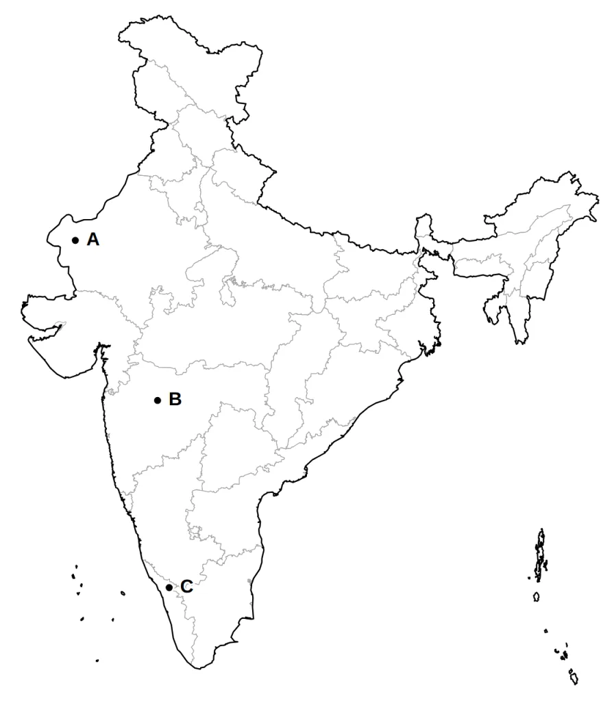
Three areas, A, B and C, are marked on the outline map of India given below. Identify the major soil type found in each area and write its name.
Answer.
Model answer:
A. Arid soil, in the dry west of Rajasthan.
B. Black soil (regur), on the lava plateau of Maharashtra.
C. Laterite soil, in the hills of northern Kerala.
Marking scheme:
- A: arid soil (western Rajasthan) — 1 mark
- B: black soil, also called regur (Deccan plateau of Maharashtra) — 1 mark
- C: laterite soil (Kerala) — 1 mark
Question 2 (2 marks)
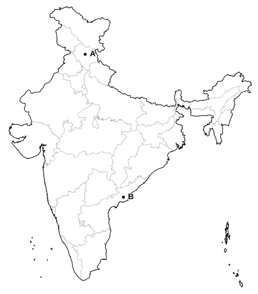
Two areas, A and B, are marked on the outline map of India given below. Identify the major soil type found in each area and write its name.
Answer.
Model answer:
A. Forest soil, in the mountain valleys of Himachal Pradesh.
B. Alluvial soil, on the Godavari delta on the coast of Andhra Pradesh.
Marking scheme:
- A: forest soil, also accepted as mountain soil (the Himalaya of Himachal Pradesh) — 1 mark
- B: alluvial soil (the Godavari delta, Andhra Pradesh) — 1 mark
Question 3 (2 marks)
In a riverside district, a few contractors dig sand out of the river bed day and night and sell it in distant cities. The river banks are caving in, and the villagers get nothing from the trade. Which two problems of the indiscriminate use of resources does this show?
Answer.
Model answer:
- The sand is being used up to satisfy the greed of a few, much faster than the river can replace it.
- The profit collects in a few hands, so the contractors grow rich while the villagers stay poor.
Marking scheme:
- Depletion of a resource to satisfy the greed of a few: the sand is dug out much faster than the river can replace it, and the banks are damaged. — 1 mark
- Accumulation of resources in a few hands: the contractors get rich while the villagers gain nothing, which divides society into the rich and the poor. (Also accept: environmental damage and land degradation.) — 1 mark
Question 4 (3 marks)
Rekha says, 'Copper is a renewable resource, because old copper wires can be melted down and used again.' Is she right? Explain the difference between renewable and non-renewable resources, and where recycling fits in.
Answer.
Model answer:
- Renewable resources are renewed by natural processes, like solar energy, water and forests.
- Non-renewable resources, like minerals and fossil fuels, take millions of years to form, so once used up they are gone.
- Rekha is wrong. Copper is non-renewable. Recycling only reuses metal already mined; fossil fuels cannot even be recycled.
Marking scheme:
- Renewable resources can be renewed or reproduced by physical, chemical or mechanical processes, e.g. solar and wind energy, water, forests and wildlife. — 1 mark
- Non-renewable resources take millions of years to form, e.g. minerals and fossil fuels; once used up, they cannot be replaced in our lifetime. — 1 mark
- Rekha is wrong: copper is a non-renewable mineral. Recycling only lets us use the same metal again; some non-renewable resources like metals can be recycled, while fossil fuels cannot and are used up. — 1 mark
Question 5 (3 marks)
A planning team is preparing a resource plan for a hilly district that has plenty of rivers and forests but very few roads. Explain the three stages of resource planning it should follow, giving an example from this district for each stage.
Answer.
Model answer:
- Survey, map and measure the district's rivers, forests and land, and list them.
- Build a planning structure with the right technology, skills and institutions, such as small hydel plants, trained local workers and roads.
- Match this plan with the national development plans, for example the country's energy plans.
Marking scheme:
- Identify the resources and make an inventory by surveying, mapping and measuring them, e.g. survey the rivers, forests and land of the district and record how much there is. — 1 mark
- Set up a planning structure with the right technology, skills and institutions to use them, e.g. small hydroelectric plants, trained local workers and roads to reach the resources. — 1 mark
- Match the district's resource plan with the national development plans, e.g. link its hydel power and forest plans to the country's energy and forest policies. — 1 mark
Question 6 (2 marks)
Gandhiji said, 'There is enough for everybody's need and not for anybody's greed.' What did he mean, and whom did he blame for the depletion of resources?
Answer.
Model answer:
- Resources can meet everyone's basic needs, but never the endless wants of the greedy, so we must use them with care.
- He blamed greedy, selfish people and the exploitative nature of modern technology.
Marking scheme:
- Meaning: the Earth's resources can meet the basic needs of all people, but not the endless wants of greedy people, so they must be used with care. — 1 mark
- He blamed greedy and selfish individuals and the exploitative nature of modern technology for resource depletion at the global level. — 1 mark
Question 7 (3 marks)
The alluvial plains are among the most densely populated parts of India. Explain two features of alluvial soil that account for this, and distinguish between bangar and khadar.
Answer.
Model answer:
- It covers the whole northern plains and the eastern deltas, a huge stretch of flat farmland.
- It is rich in potash, phosphoric acid and lime, so crops like sugarcane, paddy and wheat grow well and farming is intensive.
- Bangar is old alluvium with more kankar nodules; khadar is new, finer and more fertile.
Marking scheme:
- It is deposited by the Indus, Ganga and Brahmaputra river systems and covers the whole northern plains and the eastern coastal deltas, so it gives a huge stretch of flat farmland. — 1 mark
- It is very fertile, with enough potash, phosphoric acid and lime, and suits sugarcane, paddy, wheat, other cereals and pulses; so it is intensively cultivated and supports many people. — 1 mark
- Bangar is old alluvium with more kankar nodules; khadar is new alluvium with finer particles and is more fertile. — 1 mark
Question 8 (2 marks)
Why are forest soils fertile in the lower parts of Himalayan valleys but poor on the snow-covered heights?
Answer.
Model answer:
- On the snowy heights the soil gets stripped away, and it is acidic and low in humus.
- Lower down, on river terraces and alluvial fans, rivers leave fine alluvium and forests add humus, so the soil is fertile.
Marking scheme:
- On the snow-covered heights, the soil suffers denudation and is acidic, with a low humus content, so it is poor. — 1 mark
- In the lower parts of the valleys, especially on river terraces and alluvial fans, the soil is fertile, because rivers bring down and deposit fine alluvium, and the forest adds humus. — 1 mark
Question 9 (3 marks)
What is meant by sustainable development? Suggest two ways in which a growing town can follow it while using its water and land.
Answer.
Model answer:
Sustainable development means growing without harming the environment, so that the needs of future generations are not sacrificed.
- Water: harvest rainwater and treat waste water before it reaches the river.
- Land: build on barren land rather than on farms and forests, and plant trees in open spaces.
Marking scheme:
- Meaning: development should take place without damaging the environment, and development in the present should not compromise the needs of future generations. — 1 mark
- Water: harvest rainwater, recharge groundwater and treat waste water before letting it into rivers, so that water lasts for the future. — 1 mark
- Land: build on waste or barren land instead of fertile fields and forests, and plant trees in open spaces. (Accept any other sensible way.) — 1 mark
Question 10 (3 marks)
India's land has plains, mountains and plateaus. State the approximate share of each in the total land area, and one way in which each is useful to the country.
Answer.
Model answer:
- Plains, about 43 per cent: land for farming and industry.
- Mountains, about 30 per cent: they keep some rivers flowing all year and attract tourists.
- Plateaus, about 27 per cent: rich stores of minerals, fossil fuels and forests.
Marking scheme:
- Plains, about 43 per cent: they provide land for agriculture and industry. — 1 mark
- Mountains, about 30 per cent: they keep some rivers flowing all year (perennial flow) and offer facilities for tourism and ecological benefits. — 1 mark
- Plateaus, about 27 per cent: they hold rich reserves of minerals, fossil fuels and forests. — 1 mark
Long Answer and Case-Based Questions
Question 11 (5 marks)
Compare laterite soil and arid soil on any five points.
Answer.
Model answer:
- Climate: laterite forms where wet and dry seasons alternate in hot regions; arid soil forms in a hot, dry climate.
- How it forms: laterite comes from heavy leaching by rain; arid soil lacks moisture, and kankar collects in its lower layers.
- Nature: laterite is deep, acidic and poor in nutrients; arid soil is sandy, saline and red to brown.
- Humus: laterite has humus under thick forest but little under sparse cover; arid soil has almost none.
- Use: after soil conservation, laterite grows tea, coffee and cashew in the south; arid soil can be farmed only with irrigation, as in western Rajasthan.
Marking scheme:
- Climate: laterite develops in tropical and sub-tropical climates with alternate wet and dry seasons; arid soil develops in a dry climate with high temperature and fast evaporation. — 1 mark
- Process: laterite is the result of intense leaching by heavy rain; arid soil lacks moisture, and its lower horizons hold kankar because calcium content increases downwards. — 1 mark
- Nature: laterite is deep to very deep, acidic (pH below 6.0) and generally poor in plant nutrients; arid soil is red to brown, sandy and saline, so salty in places that common salt is obtained from it. — 1 mark
- Humus: laterite is humus-rich under deciduous and evergreen forests but humus-poor under sparse vegetation; arid soil lacks humus. — 1 mark
- Use: laterite grows tea and coffee on the hills of Karnataka, Kerala and Tamil Nadu after soil conservation, and red laterite suits cashew; arid soil becomes cultivable with proper irrigation, as in western Rajasthan. (Also accept distribution: laterite in the southern states, Western Ghats of Maharashtra, Odisha, parts of West Bengal and the north-east; arid soil in western Rajasthan.) — 1 mark
OR
Farmers of Saurashtra and Malwa call black soil their 'cotton soil'. Explain how this soil was formed and where it is found, give two of its features that suit cotton, and state one difficulty it poses to farmers.
Answer.
Model answer:
- Formation: climate and parent rock together; it formed from the lava (basalt) of the north-west Deccan.
- Where: the plateaus of Maharashtra, Saurashtra, Malwa, Madhya Pradesh and Chhattisgarh, and the Godavari and Krishna valleys.
- Moisture: its very fine clay holds moisture well.
- Nutrients: it is rich in calcium carbonate, magnesium, potash and lime, though poor in phosphorus.
- Difficulty: it turns sticky when wet, so it must be ploughed just after the first shower or before the monsoon.
Marking scheme:
- Formation: climatic conditions together with the parent rock; it formed from the lava (basalt) that spread over the north-west Deccan plateau. — 1 mark
- Distribution: the plateaus of Maharashtra, Saurashtra, Malwa, Madhya Pradesh and Chhattisgarh, extending south-east along the Godavari and Krishna valleys. — 1 mark
- Feature 1: it is made of extremely fine clayey material and is famous for holding moisture. — 1 mark
- Feature 2: it is rich in calcium carbonate, magnesium, potash and lime (though poor in phosphoric content). (Also accept: deep cracks in the hot weather help the soil to get aerated.) — 1 mark
- Difficulty: it becomes sticky when wet, so it is hard to work unless tilled right after the first shower or in the pre-monsoon period. — 1 mark
Question 12 (5 marks)
Read about three farms and answer the questions.
Farm X lies on a steep hill slope in Uttarakhand, and every monsoon the rain washes its soil down the slope.
Farm Y is on flat, sandy land in western Rajasthan, where strong summer winds blow the topsoil away.
Farm Z is close to the Chambal river. Running water has cut deep channels through its clayey soil, and parts of it can no longer be farmed.
(a) Name the kind of soil erosion at Farm Y, and what the damaged land at Farm Z is called. (2)
(b) Suggest a suitable method of soil conservation for each of the three farms, and say how it helps. (3)
Answer.
Model answer:
(a) Farm Y has wind erosion. At Farm Z, the gullies have turned the land into bad land, called ravines in the Chambal basin.
(b)
- Farm X: terrace farming. Steps cut into the slope slow the rainwater, so the soil stays in place.
- Farm Y: shelter belts. Rows of trees break the force of the wind and hold the sand.
- Farm Z: plug the gullies with small barriers and plant grass and trees in and around them, so the roots hold the soil and water flows slower.
Marking scheme:
- (a) Farm Y: wind erosion, as the wind blows loose soil off flat land. — 1 mark
- (a) Farm Z: running water has cut gullies, turning the land into bad land; in the Chambal basin such land is called ravines. — 1 mark
- (b) Farm X: terrace cultivation; steps cut on the slope slow the water and hold the soil (common in the western and central Himalayas). (Also accept contour ploughing across the slope, along the contour lines.) — 1 mark
- (b) Farm Y: shelter belts of trees (or strip cropping with grass strips) break the force of the wind and help stabilise sand dunes. — 1 mark
- (b) Farm Z: plug the gullies with small earth or stone barriers and plant grass and trees on them, so the roots bind the soil and the water slows down. (Also accept contour ploughing on the nearby sloping fields, or any sound measure against running water.) — 1 mark
OR
Answer the following.
(a) Distinguish between sheet erosion and gully erosion. (2)
(b) Explain three ways in which human activities or defective methods of farming cause soil erosion. (3)
Answer.
Model answer:
(a) In sheet erosion, water flows as a thin sheet down a slope and removes the topsoil evenly. In gully erosion, running water cuts deep channels in clayey soil, and the land turns into bad land, like the Chambal ravines.
(b)
- Cutting forests removes the roots that hold the soil.
- Overgrazing strips the grass, and construction and mining loosen the land.
- Ploughing up and down a slope makes channels, so water rushes down with the soil.
Marking scheme:
- (a) Sheet erosion: water flows as a sheet over a large area down a slope and washes away the topsoil evenly. — 1 mark
- (a) Gully erosion: running water cuts deep channels (gullies) through clayey soils, and the land becomes unfit for farming (bad land; ravines in the Chambal basin). — 1 mark
- (b) Deforestation removes the plant cover whose roots hold the soil, so rain and wind carry it away. — 1 mark
- (b) Overgrazing strips the grass; construction and mining dig up and loosen the land. — 1 mark
- (b) Ploughing up and down the slope makes furrows that act as channels, so water rushes down and carries the soil with it. — 1 mark
Question 13 (4 marks)
Read the source given below and answer the questions that follow.
What the Patwari's Register Shows
Devgarh is a village of 450 hectares at the foot of a low hill. Its patwari keeps a register of how every plot of village land is used. This is what its latest page shows.
Crops are sown on 280 hectares. On 120 hectares of these, farmers now take a second, winter crop, using water stored behind a small check dam built six years ago. A thin forest covers 40 hectares of the hillside, and this figure has hardly changed in twenty years. The school, the new road, a brick kiln and the houses together take up 25 hectares. The village common, where cattle graze, covers 30 hectares. One plot of 15 hectares has not been sown for seven years, because its owners moved to the city. The remaining 60 hectares are rocky slopes where nothing can be grown.
(a) Under which land-use category will the 15-hectare plot be recorded? (1 mark)
Answer.
Model answer:
Culturable waste land, as it has not been cultivated for more than five years.
Marking scheme:
- Culturable waste land, because it has been left uncultivated for more than five agricultural years. — 1 mark
(b) About what share of Devgarh is under forest, and how does it compare with the forest cover that the National Forest Policy (1952) considers desirable? (1 mark)
Answer.
Model answer:
About 9 per cent (40 out of 450 hectares), far below the 33 per cent the policy considers desirable.
Marking scheme:
- About 9 per cent (40 of 450 hectares), far below the desired 33 per cent of the geographical area. — 1 mark
(c) Land use is shaped by physical factors and by human factors. Using the source, explain one physical factor and one human factor that shape land use in Devgarh. (2 marks)
Answer.
Model answer:
- Physical: the rocky hill slopes cannot be farmed, so 60 hectares lie unused and the hillside stays under forest.
- Human: the check dam, a piece of technology, lets farmers grow a second crop on 120 hectares.
Marking scheme:
- Physical factor: topography; the rocky hill slopes (60 hectares) cannot be cultivated, and the hillside is left under forest. — 1 mark
- Human factor: technology or population; the check dam lets farmers take a second crop, or the growing village needs land for a school, road, kiln and houses, or migration to the city has left a plot unsown. — 1 mark
Question 14 (4 marks)
Read the source given below and answer the questions that follow.
Rich Land, Poor People
The hills of a district in eastern India hold coal, iron ore and bauxite. Every day, lines of trucks carry these minerals away. Yet many families who live beside the mines still have no electricity, no good school and no hospital within reach. Most of the mining leases belong to a few large companies, and the profits are spent far from the district. Where a mine has been worked out and left, the land lies scarred, with heaps of waste rock all around.
A researcher who studied the district described it as rich on paper and poor in real life. She compared it with another district that has far fewer minerals but has become prosperous, because it has good roads, trained workers, and banks and cooperatives that work well. She concluded that minerals alone do not bring development.
(a) The scarred land and heaps of waste rock show which problem of the indiscriminate use of resources? (1 mark)
Answer.
Model answer:
An ecological crisis: the land has been degraded and the environment damaged.
Marking scheme:
- An ecological crisis: land degradation and damage to the environment. (Also accept: depletion of resources for the greed of a few.) — 1 mark
(b) According to the researcher, what does a region need, along with resources, in order to develop? (1 mark)
Answer.
Model answer:
Suitable technology and institutions, such as roads, trained workers, banks and cooperatives.
Marking scheme:
- Matching changes in technology and institutions, such as good roads, trained workers and working banks and cooperatives. — 1 mark
(c) The minerals of the district will not last for ever. Explain two ways in which the district can use them in keeping with sustainable development. (2 marks)
Answer.
Model answer:
- Spend part of the mining income on schools, skills and roads, so people can earn after the mines close.
- Mine carefully, and fill old pits and plant trees on them, so the land is usable for future generations.
Marking scheme:
- Use part of the mining income to build lasting assets for local people, such as schools, skills, roads and other livelihoods, so the district can prosper after the mines close. — 1 mark
- Mine carefully and slowly, and restore worked-out land by filling pits and planting trees, so the land and the environment are left usable for future generations. (Accept: recycle metals; do not waste minerals.) — 1 mark