
What Determines How Land is Used
The use of land is determined by two kinds of factors:
- Physical factors — topography (the shape of the land), climate and soil types.
- Human factors — population density, technological capability, and culture and traditions.
Where the land is flat with good soil and climate, and where people have the technology and the need, land is used intensively for agriculture and settlement.
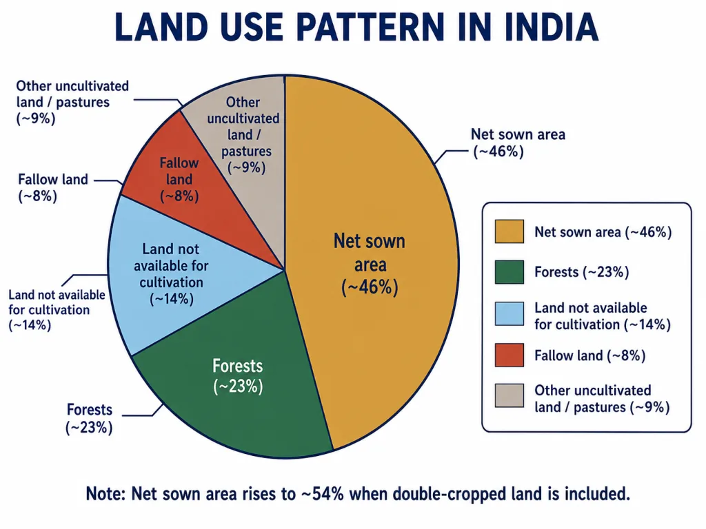
India's Land-Use Data
- The total geographical area of India is about 3.28 million sq km.
- However, land-use data is available for only about 93 per cent of this area. Reporting is incomplete for most of the north-eastern states (except Assam), and some areas of Jammu and Kashmir occupied by Pakistan and China have not been surveyed.
So when we study India's land-use pattern, we are looking at the reporting area, not the entire country.
The Pattern of Net Sown Area
The Net Sown Area (NSA) varies greatly from state to state:
- It is over 80 per cent of the total area in Punjab and Haryana.
- It is less than 10 per cent in Arunachal Pradesh, Mizoram, Manipur and the Andaman & Nicobar Islands.
When lands cultivated only once in two or three years are included, the NSA of India comes to about 54 per cent of the total reporting area.
Reason: Fertile plains with irrigation (Punjab, Haryana) have very high NSA; hilly, forested regions (the north-east) have very low NSA.
Forests and Waste Land
- The area under forest in India is far below the desired 33 per cent of the geographical area laid down in the National Forest Policy (1952). This 33% was considered essential for maintaining ecological balance, and millions of people who live on the fringes of forests depend on them.
- Waste land includes rocky, arid and desert areas.
- Land put to other non-agricultural uses includes settlements, roads, railways and industry.
- The land under permanent pasture has also decreased, which creates difficulty in feeding India's huge cattle population.
Key Point: The continuous use of land over a long time, without proper conservation, leads to land degradation.
Questions and Answers
Q1. Which factors determine the use of land? Give examples.
Answer: Land use is determined by two kinds of factors: physical factors such as topography, climate and soil types; and human factors such as population density, technological capability, and culture and traditions. For example, the fertile, level plains of Punjab (physical) combined with dense population and advanced irrigation technology (human) lead to very intensive cultivation.
Q2. Why is land-use data available for only about 93 per cent of India's area?
Answer: The total geographical area of India is about 3.28 million sq km, but land-use reporting has not been done fully for most north-eastern states (except Assam), and some areas of Jammu and Kashmir occupied by Pakistan and China have not been surveyed. Hence reliable land-use data is available for only about 93 per cent of the total geographical area.
Q3. Why is the net sown area very high in Punjab and Haryana but very low in states like Arunachal Pradesh and Mizoram?
Answer: Punjab and Haryana lie in the fertile northern plains with level land, good soil and well-developed irrigation, so their net sown area is over 80 per cent. States like Arunachal Pradesh, Mizoram and Manipur are hilly and heavily forested with steep slopes and poor accessibility, so very little land can be cultivated — their net sown area is less than 10 per cent.
Q4. The forest area in India is below the desired level. Explain.
Answer: According to the National Forest Policy (1952), about 33 per cent of the geographical area should be under forest to maintain ecological balance. India's actual forest cover is far lower than this. This is a concern because ecological balance is threatened and the livelihood of millions of people living on the fringes of forests depends on them.